
Weather System Off North Carolina Could Become Nor’Easter or Tropical Storm: What to Know

By T.J. Muscaro
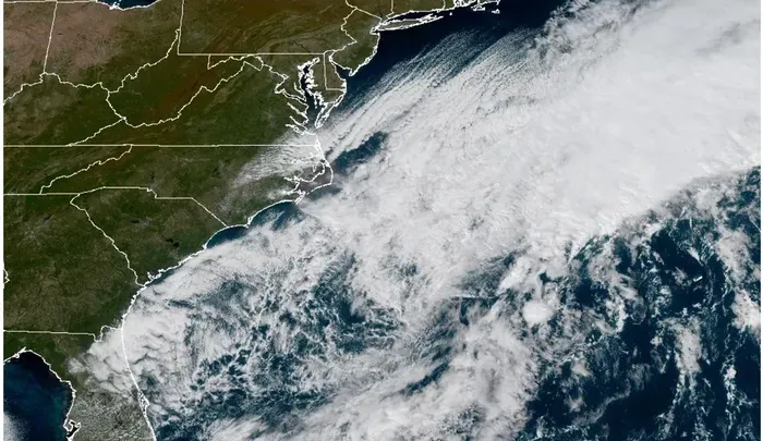
The National Weather Service and its National Hurricane Center are tracking a storm system sitting off the coast of North Carolina that has the opportunity to become either a proper Nor’easter or a Tropical Storm and is setting up either way to give the Mid-Atlantic—especially the Outer Banks—a thrashing of wind, rain, and surf.
As of the morning of Oct. 18, the National Hurricane Center said that “a storm-force non-tropical low-pressure area” was expected to form within the next 24 hours. However, the center gives this low-pressure system a 30 percent chance of becoming a subtropical storm within the next seven days.
“Regardless of development,” the National Hurricane Center warned, “this system will cause high winds, coastal flooding, and dangerous surf along portions of the U.S. East Coast. Please consult statements and warnings from local National Weather Service offices and the Weather Prediction Center for more information.”
Outer Banks Brace for Nor’easter
The Weather Prediction Center announced that a nor’easter was developing along the Carolina coast over the weekend. Its three-day forecast published on Oct. 18 predicted that it would remain offshore, thus limiting rainfall inland. But a persistent onshore flow was expected to bring serious coastal impacts to the Mid-Atlantic through Oct. 20, especially coastal flooding and beach erosion.
North Carolina’s Emergency Management office has already issued a mandatory evacuation order for visitors of Hatteras Island along the Outer Banks, the state’s iconic narrow chain of barrier islands. All ferry services except for Southport/Fort Fisher were suspended.
“This slow-moving system will bring strong winds, high waves, coastal flooding, and extremely dangerous marine conditions well into next week,” the office warned in an X post on Oct. 18. “Conditions will continue to deteriorate through the weekend, and the greatest coastal impacts are expected on the ocean side of the Outer Banks.”
A wind advisory is in effect through Oct. 20 for Hatteras and Ocracoke Islands, Eastern Currituck County, and the Northern Outer Banks, where sustained winds are expected to be 20–35 mph with gusts up to 50 mph. Another advisory stands in East Carteret County and mainland Dare County through Oct. 19, where gusts are expected to reach 45 mph.
Coastal impacts are already being recorded and are expected to continue. Hatteras and Ocracoke islands are supposed to see coastal flooding two to four feet above ground level and are under a coastal flooding warning until 5 p.m. ET on Oct. 20. Other Coastal Flood advisories span across the Outer Banks through Oct. 19. East Carteret County is expected to see two to three feet of inundation above ground level, and other areas like the Pamlico Sound and the Trent, Bay, and lower Neuse Rivers. The Albermarle Sound, Alligator River, and Scuppernong River could see one to three feet of inundation as well.
That onshore flow will come with dangerous surf conditions, including waves eight to 14 feet high and high rip current risk.
“Coastal flooding will impact soundside and oceanside locations, with the greatest coastal flooding inundation expected during Sunday and Monday’s high tide cycles, especially across oceanside locations on Hatteras and Ocracoke Islands,” North Carolina Emergency Management warned. “Areas of coastal flooding may linger well into next week due to elevated water levels.”
Both the national weather services and state-level emergency management note that this storm is very slow-moving and does not have a clearly defined track, which leaves uncertainty in their forecasts for how long affected communities can expect to face these conditions.
Nor’easter Versus Tropical Storm
From a weather satellite’s view, a fully formed nor’easter and tropical cyclone—be it a tropical storm or hurricane—can look pretty similar. They are both low-pressure systems that are known to form in the Atlantic Ocean in September, October, and November. They both generate a counter-clockwise rotation around a center, which accounts for the northeast winds that give nor’easters their name. But they are two different kinds of weather phenomena.
Two key differences are in their specific locations and fuel sources, according to the National Oceanic and Atmospheric Administration.
A tropical storm and a hurricane tend to form in the tropical and subtropical regions of the Atlantic Basin. That is defined by the Tropic of Cancer, an imaginary line that sits at about 23°27′ north above the equator. The true tropical region sits between the Tropic of Cancer and the equator, while the term “subtropical” refers to a climate type in and around that tropical zone and is recognized to extend as far north as 35° north.
Tropical storms and hurricanes also feed on warm air and water.
Nor’easters form much further north along the U.S. and Canadian coastline, and feed off cold air in the atmosphere. They are known to be more of a fall and winter storm, forming most often from September to April and bringing blizzard conditions, like heavy snowfall, along with coastal flooding.
Hatteras Island, N.C., sits at 35°13’6.00” north, along the warm northbound waters of the Gulf Stream. This means that the Outer Banks have faced both kinds of cyclones directly and indirectly over the centuries. In fact, the region suffered an earlier nor’easter only a few weeks ago.
Meanwhile, the National Weather Service’s forecast office in Newport/Morehead City, North Carolina, told The Epoch Times it remained focused on the impacts this storm is likely to have on the communities under its area of responsibility, leaving official titles to the National Hurricane Center.
As of Oct. 18, those impacts had not changed, and with persistent uncertainty in this storm’s track, the question the forecast office was working to answer was not what the locals should call it, but how long into the week it was going to impact them.
The Epoch Times reached out to the National Hurricane Center but did not hear back by time of publication.


More Stories
Wall Street Review: Nasdaq Sinks 4.48 Percent as Inflation Fears Hit AI Stocks
By Panos Mourdoukoutas The Nasdaq Composite fell 4.48 percent for the week as hotter-than-expected inflation data sent Treasury yields higher...
Republican Attorney General Candidate New York, Saritha Komatireddy, Lays Out Her Vision
By Juliette Fairley Fresh off a fiery political debate last week, Republican challenger Saritha Komatireddy on Oct. 15 laid out...
Chaos and Violence Grip France as Far-Left Mobs Storm City Halls, Torch Streets
By Etienne Fauchaire PARIS—Stones and fireworks were already flying across Place de la République before Saturday’s demonstration against rising costs...
High Gas Prices Could Be the Key Issue That Swings the Senate
By Jeremy Lott Enough voters are fixated on the price of fuel that it could be the deciding issue in...
Treasury Sanctions Iraqi Bank and Iranian Shadow Networks
By Kimberly Hayek The Treasury Department has sanctioned the Iraq-based International Development Bank for Investment and Finance (IDB) and related...
Trump Seeks to Boost Georgia Voters at Rally With Early Voting Underway
By Troy Mters DALTON, Ga.—President Donald Trump, aboard Marine One, flew directly over hundreds of supporters gathered for his rally...