Massachusetts snow totals: After some spots got 8 inches, a ‘little dry spell’ on the way
It was a feast-or-famine snow storm over the weekend, as parts of the region dug out from more than 8 inches of snow while other residents didn’t even see an inch.
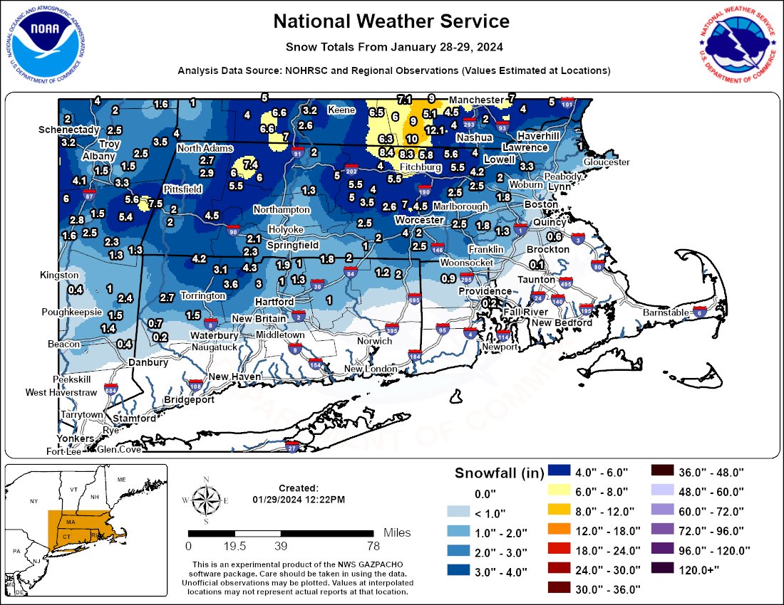
The jackpot of the storm was in northern central Massachusetts, where Ashburnham received 8.4 inches of snow and Ashby got 8.3 inches. Meanwhile at Boston Logan International Airport, less than half an inch of snow was measured.
“Now that snow has ended across much of the region & with additional snow reports, here’s a final observed snow map from reports across Southern New England from Jan 28-29th, 2024,” the National Weather Service’s Boston office posted. “Thank you for your reports! We greatly appreciate them all!”
After a very active weather pattern with several storms, it appears that the Bay State will be avoiding any significant precipitation for the next week at least.
“We’re heading into a little dry spell here,” Alan Dunham, meteorologist at NWS Boston, told the Herald.
Related Articles
Snow possible for Monday’s commute, National Weather Service says
Massachusetts snow watch: Western counties to get jackpot
Massachusetts snow forecast: Up to 8 inches in spots, Boston-area estimate ‘a little tricky’
Parts of Massachusetts could see 6 inches of snow from coastal storm: ‘Travel will be impacted’
Massachusetts on snow watch: Coastal storm could bring snow, rain, ice; ‘Everything is on the table’
On Tuesday, high pressure will deliver dry but chilly weather along with some sunshine. High temps will only be in the 20s.
“Haven’t had widespread sunshine across MA/RI/CT since last Monday,” the NWS forecast discussion reads.
After the cold day on Tuesday, temps should be on the uptick through the end of the week. Afternoon high temps on Wednesday will be in the mid to upper 30s, which is close to normal for late January.
Then on Thursday and Friday, temps should jump above normal into the 40s.
A strong cold front is expected ahead of the weekend. A cooler airmass over the Northeast will dip high temps into the 30s for the weekend, but conditions will remain quiet and dry.
“Temperatures will come back down to values closer to normal for late January or even slightly below normal,” the NWS forecast discussion reads. “Highs/lows Saturday through Monday are forecast to be in the mid to upper 30s and upper teens/low 20s respectively.”


