
Massachusetts snow watch: Meteorologists ‘keeping a close eye’ on possible storm after more rain, strong winds
The incredibly active storm stretch could continue into next week.
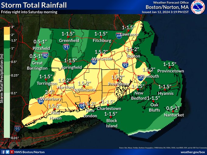
After three strong storms within the last week, including heavy rain and strong winds through Saturday, local meteorologists will be turning their attention to a possible snow storm next week.
The region may have some snow to deal with from Tuesday into Wednesday, but that’s not set in stone as of now.
“We’ll be keeping a close eye on that system,” Kyle Pederson, meteorologist at the National Weather Service’s Boston office, told the Herald on Friday.
“It looks like the system will make a close pass offshore, but there’s some possibility the system makes it onshore,” he added. “Over the next couple of days, hopefully the forecast models are in better agreement. We’ll have to wait and see over the next couple of days.”
After the region has been drenched in rain amid mild temps for January, temps will be taking a nosedive so this system would bring snow for most of the region.
“Currently model consensus favors a glancing blow with the potential for a period of light accumulating snowfall. However… still a large spread in the individual ensemble members from each model,” the National Weather Service’s forecast discussion reads.
“A stronger phasing remains possible which would bring the potential of a more significant snowfall and perhaps some Ptype issues to parts of the coastal plain,” NWS added. “In addition, a complete miss is still in the cards too where we generally just remain cold and dry. Again, given this is a day 4-5 forecast so we need to keep all options on the table. We will have a much better idea in the next 24 to 48 hours.”
Related Articles
Another one: Massachusetts braces for ‘powerful storm’ that could spark flooding, power outages
Here comes Round 3: Massachusetts will get hit by another ‘strong storm’ after nor’easter and major flooding
Avalanche kills 1, injures 3 at California ski resort that once hosted Winter Olympics
‘Strong’ storm to rip through Massachusetts after nor’easter: Flooding, power outages, damaging winds possible
Weekend snow could combine with rain and cause flooding midweek, NWS says
Before the snow watch returns in full force, the region will be drying out after another powerful rain storm leaves the area later on Saturday.
More heavy rain was expected to bring a renewed risk for river flooding, with a flood watch in effect for much of the Bay State. Wind gusts as high as 60 mph could bring isolated power outages.
Mild temps nearing 60 degrees on Saturday might approach record highs across the region.
Then it’s expected to turn colder on Sunday with high temps in the upper 30s amid blustery conditions. Monday’s high temps should only be in the low 30s, followed by mid 30s on Tuesday, and upper 20s on Wednesday.
Strong gusty winds as high as 60 mph could bring isolated power outages on Saturday. (National Weather Service map)
Water from heavy rains remains pooled near the MBTA Roxbury Crossing platform. (Chris Christo/Boston Herald)
More Stories
Meta accused of profiting from scams targeting US retirees
Advocacy groups have urged Congress to investigate claims that the tech giant benefited from fraudulent campaigns aimed at seniors Several...
Coverd and Albert Wang: Why the Next Chapter of Credit Card Rewards May Be Written Around Everyday Spending
The modern loyalty program occupies a curious place on corporate balance sheets, recorded as a liability that many issuers quietly...
What to Expect from UK Software Development Firms
In all industries, companies are making efforts to adopt digital solutions, automate processes, migrate to the cloud, and operate with...
Austen Hacker: From Concert Pianist to Pharmacy Leader
Success does not always follow a straight line, for Austen Hacker, the path to leadership in pharmacy began behind a...
Jonny Dodge: The Superyacht Influencer and Questions Over Mother City Capital
He has been called the “Superyacht Influencer” by Forbes, featured in Bloomberg, GQ, Tatler and Robb Report, and commands a...
6 Steps to Prepare for Making Tax Digital for Income Tax
Making Tax Digital (MTD) was first introduced by HM Revenue and Customs as part of a wider plan to modernise...