Nor’easter could pound Massachusetts with ‘significant plowable snow’ over the weekend
Is there about to be a run on bread and milk at the grocery store?
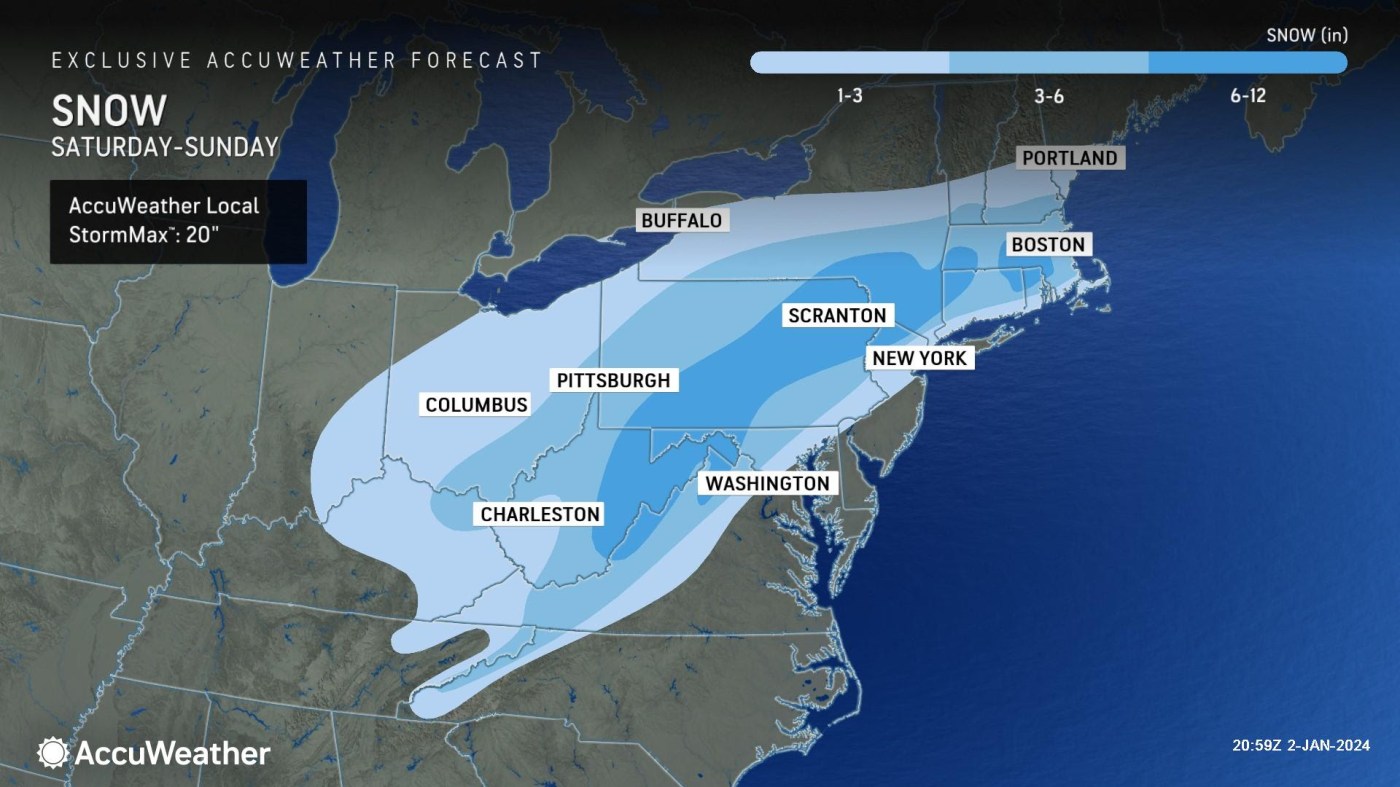
Forecasters are keeping a close eye on a possible major winter storm that may pound the region with “significant plowable snow” over the weekend.
The nor’easter could dump more than 6 inches of snow on parts of Massachusetts, according to meteorologists who said it’s still too early to determine the exact snow totals.
“It’s potentially the first significant snow storm of the winter,” AccuWeather Senior Meteorologist John Feerick told the Herald on Tuesday.
“It could cause some travel problems, especially inland where we’ll probably see the highest amounts of significant plowable snow,” he added.
The most likely spots that would see 6-plus inches of snow would be west of Boston, especially west of Interstate 495.
After a dry day on Saturday, it looks like some snow will start falling on Saturday night.
“It should be a fairly quick mover with most of the snow Sunday morning,” Feerick said. “Then the snow should taper off Sunday afternoon.”
Related Articles
New Year’s Day warmer than usual with ‘tranquil’ days to follow, NWS says
Will there be snow on Christmas? Here’s a look at the weather for the week ahead
Another strong storm to hit Massachusetts with heavy rain, strong winds, flooding: ‘Plan ahead if traveling’
Massachusetts to get pounded by strong storm: Heavy rain, damaging winds, flooding, power outages possible
Massachusetts could see some snow: Where’s the best chance for 2-plus inches?
There is still considerable uncertainty with this system. It depends on the exact track of the storm.
If the low pressure system takes a more southerly track, there would be more widespread snowfall across the region. But if the system has a more northerly track, then there would be a higher chance for a mix of rain and heavy wet snow along southeastern Massachusetts and the Cape and Islands.
“We’ll be honing in on the track toward the end of the week, and we’ll see where the highest totals end up,” said Rob Megnia, a meteorologist with the National Weather Service’s Boston office.
There could be a “pretty good amount of snow,” he added.
The last significant snowfall in Boston was way back in February of 2022, when 8.5 inches fell on Feb. 25.
“That could be in the cards for the Boston-area, but it’s track dependent,” Megnia said.
“There’s a lot of uncertainty this far out, so I wouldn’t commit to any specific snowfall,” he added. “The forecast will have more details by the end of the week.”
Only 11 inches of snow was recorded in Boston during all of 2023 — the fourth least snowy year in the city’s recorded history. Cities from Washington, D.C. to New York City have not had an inch of snow in about 700 days.
This storm could bring some strong winds along the coast, possibly sparking some coastal flooding.
The main element of the system was moving into northern California on Tuesday. The system was expected to cross the Rockies and then the southern Plains.
“The low pressure system will head northeast toward us, with the worst of the snow north and west of I-95,” Feerick said. “Virginia up through Maine could be impacted by this.”
Some forecast models show a 50% to 80% chance of snow accumulations of 3-plus inches in the interior portion of southern New England.
“Will continue to monitor but given the trends in the models and ensembles, it’s fair to say there are growing chances on some sort of storm system early Sunday morning into a good part of Sunday/Sunday night,” the National Weather Service’s forecast discussion reads.
“Wintry weather is also looking more possible in Southern New England, but particularly in interior sections,” NWS added. “But there are still unresolved uncertainties in storm track and precip types/duration to provide any more specifics.”
The salt pile at Eastern Minerals in Chelsea is ready for the upcoming storm season. (Nancy Lane/Boston Herald)

