
Massachusetts snow forecast: Up to 4 inches possible in season’s ‘first accumulating snow’ for spots
It could start to look a lot more festive around these parts.
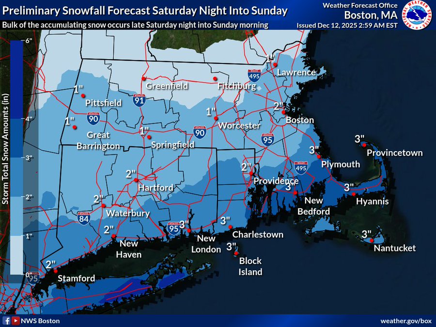
The “first accumulating snow” of the season for much of eastern Massachusetts is on the way, less than two weeks out from Christmas.
Local meteorologists are predicting about 1 to 2 inches of snow south of the Mass Pike, and possibly a swath of 3 to 4 inches near the South Coast this weekend. A dusting to 1 inch of snow is expected north of the Mass Pike.
The track may still shift north or south, so forecast adjustments are possible.
The fast-moving low pressure system will arrive Saturday night, and the bulk of this snow will fall later Saturday night into Sunday morning — before the big Patriots game in Foxboro.
“This will be the first accumulating snow event of the season for much of eastern MA/RI and even parts of CT,” the National Weather Service’s Boston office wrote.
“Fortunately, the bulk of the snow will fall late Sat night into Sun morning when travel is on the lighter side,” NWS Boston added. “Nonetheless, untreated roads will likely be snow covered and slippery especially those traveling early Sunday morning.”
If the system’s track is further north, there could be 3 to 5 inches of snow south of the Mass Pike, and 1 to 3 inches north of the Pike.
If the system’s track is suppressed even further south, that would result in little if any snowfall north of the Pike — with just a coating to 1 inch south of the Pike.
Those further north and south outcomes have lower probabilities, but meteorologists say they still need to be considered.
While the majority of any accumulating snow will have ended by Sunday morning, ocean effect snow showers may persist on the Cape and Nantucket into Sunday evening. That could lead to an inch or two of additional snowfall across parts of this region.
Related Articles
Winter storm dumps snow, rain across southern New England
Massachusetts snowstorm: Which areas could see more than 6 inches of snow?
Boston Weather: Tuesday snowstorm to hit Massachusetts [+see snow prediction]
Following the snow, a shot of arctic air is expected Sunday night into Monday.
“Wind chills will likely be down to between -5 and 10 above Monday morning!” NWS Boston wrote.
Highs on Monday will only be in the 20s.
It remains chilly for Tuesday, with highs in the upper 20s to mid-30s.
But a pattern change with significantly milder temps are likely for Wednesday and especially by Thursday, when highs may break 50 in spots.
NWS Boston added, “So this will be significantly milder weather than what we have been experiencing so far in December.”


More Stories
Trump orders 301 investigation into EU over Google’s €890m fine
Donald Trump has said the United States will “immediately initiate a 301 investigation” into the European Union and is considering...
Burnham rules out early election as poll puts Labour on 209 seats
Labour would be the largest party in the House of Commons but fall 117 seats short of an overall majority...
Oil back at $100: Time to worry?
Renewed hostilities between the US and Iran, coupled with Houthi attacks in the Red Sea, are raising concerns as global...
US regulator rejects Wise application for banking licence
Wise has been refused a US banking licence, the payments company said, months after switching its primary stock market listing...
What Alpha Generation Actually Means in Trading
Most people who spend time around financial markets have heard the word “alpha” thrown around. It gets used loosely, sometimes...
Future-Proofing SMB Marketing: Scaling Visual Content with Pollo AI
In the current business landscape, small and medium-sized enterprises (SMBs) are operating in an environment that demands more content than...