Nasty Nor’easter could dump snow in parts of Massachusetts, bring strong winds, spark power outages
No, sadly this is not an April Fools’ joke.
Old Man Winter just doesn’t want to call it quits for the season, as a nasty nor’easter is set to blast Massachusetts with several inches of snow for parts of the region.
The strong storm, which is expected to start Tuesday night and stay until Thursday, will likely deliver powerful gusty winds and drop buckets of rain on most areas. There will be a threat for power outages, along with river flooding and coastal flooding concerns.
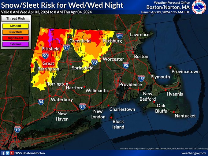
It looks like all rain for the Boston-area, while the National Weather Service’s greatest confidence for snow accumulation is across the northern Worcester Hills and northern Berkshires.
NWS has issued a “Winter Storm Watch” for western Franklin and western Hampshire counties, where meteorologists are forecasting a chance for more than 7 inches of snow.
“As you go out west into the higher elevations, wet snow will fall especially on Wednesday night,” NWS Boston meteorologist Andy Nash told the Herald.
“There could be a few inches across the Worcester Hills,” he added. “The higher you are, the more snow there could be. Also, wet snow could be sticking to trees and power lines, which could result in some power problems.”
Very windy conditions, with gusts in the 50 mph range, adds to the power outage potential.
Winds should peak Wednesday night into Thursday, especially for the eastern Massachusetts coast and in the higher terrain.
As for northern Worcester County, the chance for more than 3 inches of snow is between 50% and 70% based off model estimates. In the city of Worcester, there’s a 25% chance for up to an inch of snow.
Related Articles
Parts of Massachusetts have a 50-50 shot at seeing a foot of snow this week
Massachusetts could get some snow as coastal storm looms: ‘We’ve had several April snow storms’
Parts of Massachusetts could see snow before heavy rain, flooding possible: ‘A complete washout’
Get Jim Cantore to Massachusetts: Thundersnow reported amid ‘epic snow squall action’
Snow?! Massachusetts could see some accumulating snowfall for first spring weekend
Outside of the higher elevations, the rain is expected to begin Tuesday afternoon, with the heaviest coming down Wednesday and Wednesday night.
“It’s a fairly long duration storm, and when it all comes to an end on Thursday, the Boston-area is looking at upwards of a couple inches of rain,” Nash said.
Saturated ground and swollen rivers from recent heavy rain could lead to urban or poor drainage flooding, with a renewed risk for minor river flooding.
Also, there will be a chance for coastal flooding around the Wednesday evening and Thursday morning high tides. The greatest potential on the eastern Massachusetts coast will be Thursday morning. In Boston Harbor, high tide takes place at around 6:35 a.m. on Thursday.
Meanwhile, parts of New Hampshire and Maine could be in store for a whopper of a snow storm. More than 18 inches of snow will be possible in northern New England from the April nor’easter.
“Visibilities may drop below 1/4 mile due to falling and blowing snow,” NWS warns. “The strong winds and weight of snow on tree limbs may down power lines and could cause scattered to numerous power outages. Significant snowfall and periods of heavy snowfall rates will combine with low visibility to create very dangerous driving conditions.”


