Parts of Massachusetts could see snow before heavy rain, flooding possible: ‘A complete washout’
Believe it or not, here comes some snow and wintry weather.
Some regions of the Bay State were expected to see a bit of snow, ice and freezing rain early Saturday, as local meteorologists warned of hazardous road conditions.
The National Weather Service issued a “Winter Weather Advisory” for parts of central and western Massachusetts, especially for the higher terrain in the northern spots.
“Anyone traveling early Saturday morning along Route 2, you’ll want to drive with caution,” Rob Megnia, a meteorologist at the National Weather Service’s Boston office, told the Herald.
The freezing rain, along with ice, is more of a concern than the minor snow accumulations.
Ice accumulation of a few hundredths of an inch to a tenth will likely lead to dangerous travel.
“Precipitation will initially spread from west to east as snow, before transitioning to a wintry mix of rain, freezing rain, sleet, and snow, and ultimately to all rain,” NWS wrote in its winter weather advisory. “Sheltered valleys may see a later transition to rain and higher accumulations of ice and snow.”
“Plan on slippery road conditions… Slow down and use caution while traveling,” NWS added.
Related Articles
Get Jim Cantore to Massachusetts: Thundersnow reported amid ‘epic snow squall action’
Snow?! Massachusetts could see some accumulating snowfall for first spring weekend
After mixed snow and rain in Massachusetts, temps ‘plunge’ before some ‘unsettled’ weather
Here’s how to have a snowmobiling adventure in Colorado
The Massachusetts snowstorm that went missing (for most) after schools closed, Michelle Wu says city ‘glad to be safe, rather than sorry’
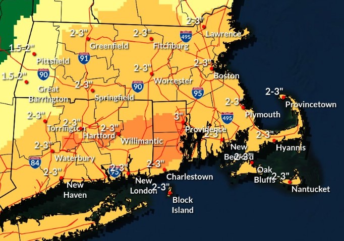
Meanwhile, the rest of the state will be facing a deluge of rain throughout the day on Saturday. Forecasters are predicting heavy rain — with widespread totals of 2 to 3 inches, and locally higher amounts possible.
The heavy rain could spark flooding.
“It’s going to be a pretty significant rain storm,” Megnia said. “A complete washout.”
The National Weather Service issued a “Flood Watch” for much of the region. The heaviest rain should occur Saturday afternoon and evening, which may lead to urban and poor drainage street flooding, as well as sharp rises on rivers and streams. Some river flooding is possible.
“Those living in areas prone to flooding should be prepared to take action should flooding develop,” NWS warned.
While not a primary hazard, gusty southeast winds will be likely Saturday afternoon into Sunday morning. Wind gusts of 30 to 40 mph are possible.
Meanwhile up north, the National Weather Service has issued a “Winter Storm Watch” for parts of New Hampshire and Maine, where more than 6 inches of snow will be possible.
NWS warned, “Periods of moderate and heavy snow will combine with low visibility to create dangerous driving conditions.”
Following Saturday’s storm, Sunday should be dry across Massachusetts, but it’s expected to be quite windy especially along the coast. Forecasters are predicting 40 to 50 mph wind gusts along Cape Cod, and even stronger winds up to 55 mph will be possible on Nantucket.

