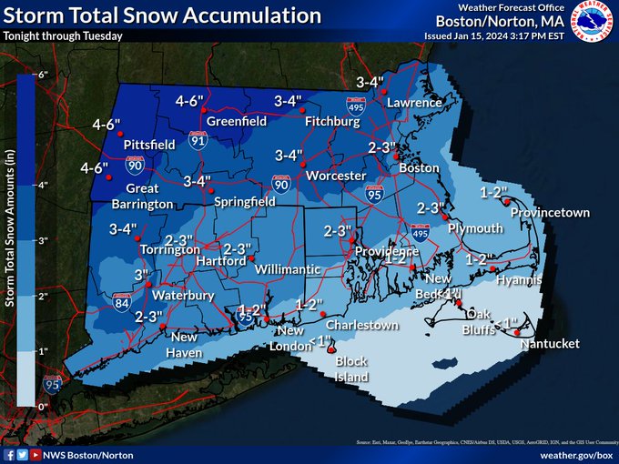
Parts of Massachusetts could see 6 inches of snow before another possible coastal storm
The morning commute after the holiday weekend could definitely take longer than usual.
Some spots in the Bay State might see up to 6 inches of snow, as a coastal storm brings accumulating snow and some ice to the region on Tuesday. The snow forecast for the Boston-area is 2 to 3 inches.
“There could be some snow patches on area roadways for the morning commute,” Alan Dunham, meteorologist at the National Weather Service’s Boston office, told the Herald on Monday.
“I would expect a little bit longer commute than normal for Tuesday morning,” Dunham added.
Some students will have an extended long weekend due to the snow. Worcester Public Schools will have a snow day on Tuesday.
“Due to the forecast and timing for accumulating snow, all @worcesterpublic schools will be closed Tuesday, January 16,” Worcester Schools posted. “Head Start and before- and after-school activities are canceled. Please stay off roads & stay safe.”
The National Weather Service has issued a “Winter Weather Advisory” for much of Massachusetts through 7 p.m. on Tuesday. In addition to the snow, mixed precipitation is expected. There could be ice accumulations of a light glaze.
Snow-covered roads followed by an icy mix will result in some slick travel.
“Plan on slippery road conditions,” the NWS advisory reads. “The hazardous conditions could impact the morning or evening commute… Slow down and use caution while traveling.”
Total snow accumulations are expected to be 1 to 3 inches south of the Mass Pike, and 3 to 5 inches north of the Pike.
The snow is expected to change to sleet and freezing rain around midday along the Interstate 95 corridor, and to plain rain south and east of I-95 in the morning.
Related Articles
The ‘coldest period of winter’ on the way to Massachusetts, NWS says
Boston records near-record tide as region floods
Watertowners will soon have to shovel sidewalk snow
Massachusetts snow watch: Meteorologists ‘keeping a close eye’ on possible storm after more rain, strong winds
Another one: Massachusetts braces for ‘powerful storm’ that could spark flooding, power outages
The precipitation will likely come to an end early Tuesday evening.
Then it should turn sunny on Wednesday, but temps will be cold. High temps will only hit the upper 20s.
Thursday is expected to be partly sunny, with a high temp around 30 degrees.
“We’re going to have a pretty cold week,” Dunham said.
Then another coastal storm may impact the region on Friday.
“We’ll have another chance for snow, but it’s still too early to tell how much,” Dunham said.
The coastal storm could just be a “glancing blow.”
“Still a lot of spread in potential storm track and intensity but consensus of the ensemble suite is the storm remaining far enough offshore for just a glancing blow,” the National Weather Service’s forecast discussion reads. “However, it’s still day 4 and there are some members with a more significant impact.
“It will depend on the amplitude of this northern stream shortwave and if it can back the flow enough for a low track closer to SNE,” NWS added. “At the very least, a period of light snow is anticipated, with greater probs near the coast, but can’t rule out a more significant impact.”
Then it’s expected to be blustery and cold this weekend behind the storm. The coldest day will be Saturday with highs in the upper teens to mid 20s, with lows in the single numbers and low teens. Subzero wind chills will be likely late Friday night and Saturday morning, and again Saturday night and Sunday morning.
A runner braces the cold as they head around Jamaica Pond on Monday. (Libby O’Neill/Boston Herald)
From left, Newton’s Victor Cruz, Brookline’s Lucia Noava, Jose Vicaio Ocana, and Brookline’s Carmen Noava bundle up as they walk around Jamaica Pond. (Libby O’Neill/Boston Herald)


