
Nor’easter set to blast Massachusetts with up to 12 inches of snow, Patriots could have a snow game
Good luck at the grocery store over the next couple of days.
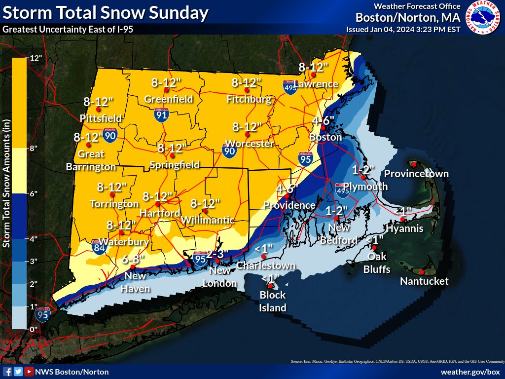
The first snow storm of the season is set to blast the Bay State this weekend, dumping up to 12 inches of snow across the region.
A “Winter Storm Watch” will be in effect from Saturday evening through Sunday night, as the nor’easter will likely drop significant snowfall and spark hazardous road conditions.
The Winter Storm Watch zone is mostly west of the Interstate 95 corridor in Massachusetts — with a widespread 8 to 12 inches of snow forecasted for the region.
“People should definitely take it slow out there on Sunday,” Kyle Pederson, meteorologist at the National Weather Service’s Boston office, told the Herald on Thursday.
It looks like the snow will start Saturday evening, sometime after sunset and before midnight. Then it should wrap up on Sunday between 6 p.m. and midnight.
The Patriots’ final game of the season, home against the Jets, will be at 1 p.m. on Sunday. Snow football at Foxboro’s Gillette Stadium is “certainly possible,” Pederson said.
“The heaviest snow will be before the game,” he added. “There should be lingering snow during the game.”
Fans heading to the game could be dealing with some tough travel, the meteorologist noted.
Related Articles
Nor’easter expected to dump snow across Massachusetts before a ‘stronger storm’ next week
Nor’easter could pound Massachusetts with ‘significant plowable snow’ over the weekend
New Year’s Day warmer than usual with ‘tranquil’ days to follow, NWS says
Will there be snow on Christmas? Here’s a look at the weather for the week ahead
Another strong storm to hit Massachusetts with heavy rain, strong winds, flooding: ‘Plan ahead if traveling’
Forecasters are least confident about the snow totals inside the I-95 corridor due to the fluctuation of the rain/snow line along the coast.
The snow total forecast for the city of Boston is 4 to 6 inches.
“That could certainly change over the next couple of days,” Pederson said. “We’ll get better guidance on where the rain/snow line ends up.”
Snow totals are expected to be lower along southeastern Massachusetts and the Cape and Islands, with rain mixing in there.
“The closer to the coast, the wetter the snow is going to be,” said AccuWeather Senior Meteorologist Tom Kines. “The farther inland, the drier the snow is going to be.
“For shoveling, if you’re close to the coast, it’s going to be a bear to move around,” he added. “Whereas inland, those places will have a drier snow, so it will be easier to move around.”
Winds might gust as high as 40 mph in the interior, while wind gusts could be whipping up to 55 mph along the Cape and Islands. Beach erosion and coastal flooding will be possible.
Also, power outages may happen along the rain/snow line.
“That heavier, wet snow could weigh down tree limbs and power lines,” Pederson said.
The Massachusetts Emergency Management Agency is reminding residents about the safety steps they should take ahead of the winter storm.
“Have emergency supplies for your home and car,” MEMA posted. “Manually check your smoke & CO detectors. Verify you have sufficient fuel for your vehicle and home heating sources.”


More Stories
El papa León visitará 4 países africanos como parte de su apretada agenda de viajes de 2026
Por NICOLE WINFIELD ROMA (AP) — El Vaticano anunció el miércoles un intenso y prolongado calendario de viajes al extranjero...
Iran pushes back against Trump ahead of Geneva talks in face of major US military deployment
By JON GAMBRELL DUBAI, United Arab Emirates (AP) — Iran pushed back Wednesday against President Donald Trump’s pressure tactics ahead...
Iran pushes back against Trump ahead of Geneva talks in face of major US military deployment
By JON GAMBRELL DUBAI, United Arab Emirates (AP) — Iran pushed back Wednesday against President Donald Trump’s pressure tactics ahead...
Reform vows to scrap Renters’ Rights Act, warning of ‘job-killing’ regulation
Reform UK has pledged to abolish the government’s Renters’ Rights Act if it wins the next general election, describing the...
Trump plans to take his State of the Union message on the road — eventually
By SEUNG MIN KIM WASHINGTON (AP) — President Donald Trump has delivered the State of the Union. Now the challenge...
Trump plans to take his State of the Union message on the road — eventually
By SEUNG MIN KIM WASHINGTON (AP) — President Donald Trump has delivered the State of the Union. Now the challenge...