
DC region under Winter Weather Advisory: Rain transitioning to wet snow
Some D.C. residents may be experiencing weather whiplash as Saturday was springlike but temperatures have dropped to transition rain into wet snow; the National Weather Service has issued a Winter Weather Advisory for parts of the region with snowfall expected to end Sunday afternoon.
Warm temperatures nearing 60 moved out to make way for wintry weather Sunday. Here’s what you need to know.
- The Winter Weather Advisory is active through 4 p.m. and includes most of the D.C. area. Parts of Southern Maryland and Stafford and Spotsylvania counties in Virginia are excluded from the advisory.
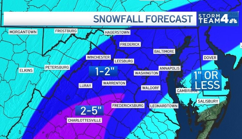
- Snow will be wet and should accumulate around 1 to 2 inches.
- Roads could be wet, use caution on bridges and overpasses.
- Potential for a refreeze Monday morning.
“The ground and pavement is warm, and it will take awhile for us to see much accumulation,” Storm Team4 Meteorologist Mike Stinneford said. “Look for up to 2 inches of snow, mainly on the grass.”
The snow looks to be a “low-impact system,” with rain transitioning to all wet snow as the atmosphere finally cools enough for winter weather. Then it’ll start to barely accumulate, mostly on grassy surfaces, before ending, according to Storm Team4 Meteorologist Matt Ritter.
Light snow will continue into early this afternoon with periods of moderate snow at times. If traveling today, exercise caution while driving and allow for extra travel time. pic.twitter.com/vgsNvRuErB
— NWS Baltimore-Washington (@NWS_BaltWash) February 13, 2022
The snow should stop by the early afternoon in most parts of the D.C. region, according to the NWS.
Stinneford said roads should be mainly just wet with some slick spots on bridges and overpasses.
But there is an expected refreeze on Monday morning as temperatures are expected to plummet further Sunday night and into Monday.
“Any standing water will freeze, and roads may become slick,” Stinneford said.
The National Weather Service (NWS) for the Baltimore-Washington Area is warning those living in the area too not be fooled by the warm temperatures on Saturday.
While today will be mild, breezy and dry, the old adage “Red sky at morning, sailors take warning” will be apt today as temperatures fall rapidly tonight, with rain changing to snow for most of the area by early Sunday morning. Our latest forecast is at https://t.co/ZOlvERZ7E7 pic.twitter.com/yxUWMB6kqa
— NWS Baltimore-Washington (@NWS_BaltWash) February 12, 2022
While there is not expected to be much accumulation for the immediate D.C. region, some areas like the Blue Ridge region are expecting much higher totals, according to the NWS.

- Listen to WTOP online and on the radio at 103.5 FM or 107.7 FM.
- Current traffic conditions
- Weather forecast
- Closings and Delays
- Sign up for WTOP alerts
Forecast:
TONIGHT: Partly to mostly cloudy and colder. Standing water on area roadways will freeze. Lows in the low to mid 20s.
MONDAY: Very cold with icy spots in the morning. Mostly sunny, brisk and chilly the rest of the day. Highs in the mid to upper 30s.
TUESDAY: Mostly sunny and seasonably chilly. Highs in the low to mid 40s.
WEDNESDAY: Increasing cloudiness and warmer. Highs in the low to mid 50s.
Current conditions:


More Stories
Apple launches Klarna device leasing in US from $17.99 a month
Apple launched a hardware leasing programme provided by Klarna on Tuesday, with iPhone leases starting at $17.99 a month and...
University College Birmingham buys former Cube hotel in £15m plan
University College Birmingham has acquired the former The Cube Hotel and Marco Pierre White restaurant in Birmingham city centre, the...
US bans Chinese humanoid robots
The measure comes amid an intensifying rivalry between Beijing and Washington to dominate in advanced technology and AI Washington announced...
Masaj raises £1.5m to open three more London studios
Masaj, the London massage chain, has raised £1.5 million to open three further studios in the capital over the next...
Steph McGovern to host UK’s first Vocational Celebration Day
The UK’s first Vocational Celebration Day will take place on Thursday 6 August, nine days after Prime Minister Andy Burnham...
Late payments will limit £2bn lending expansion, credit firm says
Credit management firm Darcey Quigley & Co has said the expansion of the Growth Guarantee Scheme will not deliver its...