Massachusetts could see an ‘impactful winter snow storm,’ bombogenesis ‘cannot be ruled out’
Will the pre-Valentine’s Day storm lead to snow much fun for kids across the area, or will the storm be flaky and barely kiss the region?
It’s the question that meteorologists are trying to solve, as the forecast models for a possible significant coastal storm early next week remain quite fuzzy.
Bombogenesis, also known as a bomb cyclone, is also a possibility with this uncertain system.
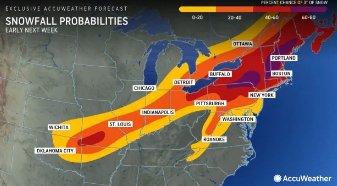
“We’re tracking the potential for an impactful winter storm across the Northeast, likely from late Monday into Tuesday,” AccuWeather meteorologist Isaac Longley told the Herald on Thursday.
“There is a lack of cold air, so the system could bring a mix of rain and snow closest to the coast, while there could be more significant snow across the inland and higher terrain,” the forecaster added.
A few different elements currently located in the western U.S. will have to come together to form a potent storm.
Meteorologists are also saying that bombogenesis — when a storm rapidly intensifies, or strengthens, over a 24-hour period — could happen.
“That certainly cannot be ruled out at this point,” Longley said. “There’s certainly the potential for the system to quickly strengthen as it emerges off the coast.
“The most likely timeframe is Monday night into Tuesday morning when we could see that rapid strengthening,” the meteorologist added.
Bombogenesis can happen when a cold air mass collides with a warm air mass, such as air over warm ocean waters.
Euro ensembles 1am to 7am Tuesday. #Bombogenesis
It’s a close track for the shoreline but quite a signal for a storm. pic.twitter.com/137cRQxIOG
— eweather (@Eweather13) February 8, 2024
Related Articles
Massachusetts snow storm watch: A ‘significant coastal storm’ could hit the region next week
Massachusetts snow totals: After some spots got 8 inches, a ‘little dry spell’ on the way
Snow possible for Monday’s commute, National Weather Service says
Massachusetts snow watch: Western counties to get jackpot
Massachusetts snow forecast: Up to 8 inches in spots, Boston-area estimate ‘a little tricky’
Near record-high warmth is expected on Saturday with temps well into the 50s for many locations. But then colder air arrives for next week.
The coastal storm’s impacts for southern New England remain quite uncertain, according to the National Weather Service.
“This is not an easy forecast,” said Andy Nash, meteorologist with the National Weather Service’s Boston office. “We don’t know the exact track of the system, and we don’t have a good feel on whether it will be all snow, all rain, or a mix of rain and snow.
“Right now, the best guess is there’s a better chance for snow across the interior areas and rain for the southern areas,” Nash added. “The forecast is bound to change quite a bit between now and the next few days.”
Coastal flooding will also be a concern given the high astronomical tides and strong wind potential.


