
Greater Boston warned to brace for 2 feet of snow, at least a foot elsewhere in Massachusetts
Greater Boston is being warned to brace for up to 2 feet of snow. That’s sure to bring out the odd space savers in Southie for days.
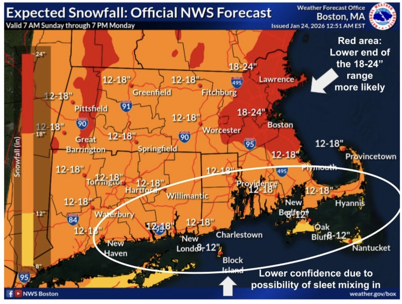
The National Weather Service a.m. update (posted online at 3 this morning) states the city could see 18 to 24 inches of snow from this storm heading our way. That’s a significant adjustment from yesterday. They alert that it is “Hot off the press.”
And the newly formed red zone inches out to Route 128, so Greater Boston communities could also be in this jackpot snowfall category. The South Shore and North Shore are also in the red deep-dump region. I’ll let you guess if that’s you.
Hot off the press, here’s the latest snowfall forecast for the storm that arrives on Sunday, peaks in intensity Sunday evening/night then trails off with light snow on Monday. Check your local forecast at https://t.co/vHZv91Q1be! pic.twitter.com/xjkzrBQXQG
— NWS Boston (@NWSBoston) January 24, 2026
A corresponding map of Massachusetts places Cambridge to Newton; Saugus to Salem; Quincy to Weymouth all in this NWS 2-foot, red-painted, shovel-ready, 2-foot region.
The timing, of course, is key. The NWS states “snow arrives 9 a.m. to 3 p.m.” on Sunday and depending where you live, the heaviest snowfall kicks into gear from 3 p.m. tomorrow through 1 a.m. Monday.
“Light to moderate snow lingers through much of Monday,” the meteorologists add, “especially in central and eastern Massachusetts.”
This poses a sticky problem for plows, and those lucky ones with snowblowers, because the heavy snowfall ebbs at 1 a.m. The best course of action, for homeowners, is to wake up Monday to begin digging out.

More Stories
‘I’m praying they get policy right’: Dimon puts Burnham on notice
Jamie Dimon has handed Andy Burnham’s day-old government both a vote of confidence and a warning shot. The JP Morgan...
Farmers to Burnham: you said the family farm tax ‘needs looking at again’
Andy Burnham has been in Downing Street for barely a day, and rural Britain has already presented him with his...
Definitely maybe: what PM Andy Burnham means for British business
I went to the Hacienda exactly once, in the early nineties, a Londoner up for the weekend who queued for...
Why Your Team Is Your Most Underused Marketing Channel on LinkedIn
A mid-sized company can spend months perfecting a LinkedIn page that a few hundred people follow, while the audience it...
Visa turns to Rightcharge as 73% of fleet charging moves home
British EV charging specialist Rightcharge has been certified as Visa’s only recommended home charging reimbursement partner in Europe, a tie-up...
Searches for ‘VAT definition’ leap 23% as filing deadline looms
Britain’s business owners are quietly Googling their way through VAT season. Searches for “VAT definition” have jumped 23 per cent...