Massachusetts could get snow, ‘wintry weather’ around Thanksgiving, Black Friday
Dreaming of a white… Thanksgiving?!
Christmas could be coming early for kids this year, as local meteorologists keep a close eye on whether a possible snow storm hits the region around Thanksgiving and Black Friday.
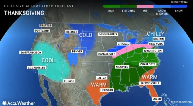
“There’s potential for a storm at the end of the holiday week,” AccuWeather Senior Meteorologist Bob Larson told the Herald. “There’s a chance for rain or snow, which looks like it could begin late on Thanksgiving and could go until Friday night.
“The storm track will determine the form of precipitation, and as always, there’s potential for changes in timing,” he added. “If it speeds up, precipitation could arrive earlier on Thanksgiving, and if it slows down, the storm could arrive later on Friday.”
The forecast model guidance for the potential storm was “all over the place” about a week out, according to National Weather Service meteorologist Kyle Pederson on Friday.
“We’re tracking a possible storm system, any time between Thursday and Saturday,” said Pederson, who’s with the National Weather Service’s Boston office. “Right now, it’s looking like Friday if it does happen. We could have some wintry precipitation with this.”
It was still too early to give out any snowfall inch predictions this far out.
“As we move toward Monday, Tuesday, we should have a good handle on it,” Pederson added of the forecast.
If New York City sees this storm with possible strong wind gusts early in the day on Thursday, that could affect the Macy’s Thanksgiving Day Parade.
A Pacific frontal system is expected to move across the country, leading to a developing storm system in the Central Plains.
“Quite a bit of uncertainty exists in the details, though there appears to be enough colder air in place to allow for some wintry weather possibilities Thurs and/or Fri, provided there is a favorable storm track,” the National Weather Service’s Boston office wrote in its forecast discussion.
“Kept PoP (probability of precipitation) on the higher end of Chance but will be monitoring model developments very closely,” the NWS Boston office added.
Related Articles
Massachusetts should get ‘much-welcomed’ rain, even snow in spots amid ‘Critical Drought’ as wildfires keep burning
When it comes to traveling ahead of the holiday, Monday looks like it will be a dry and less windy day for travel following a blustery weekend.
Then on Tuesday, there could be some rain showers, which don’t look too heavy.
“Rain looks more showery than steady rain at this time, but a shift south in the low-pressure track could bring more consistent rain,” the National Weather Service’s forecast discussion reads. “The highest… totals will likely be north of the MA pike, closer to the better forcing, but likely remain under a half inch.”
A cold front then moves through late Tuesday, drying things out and bringing gusty northwest winds again for
Wednesday. Winds look to be around 15 to 20 mph with gusts of 25 to 30 mph for much of the day.


