Massachusetts to get pounded by strong storm: Heavy rain, damaging winds, flooding, power outages possible
A strong December storm is expected to blast the region at the end of the weekend, likely causing some headaches for the Monday morning commute.
But you won’t need to bust out your snow shovels and snow blowers quite yet.
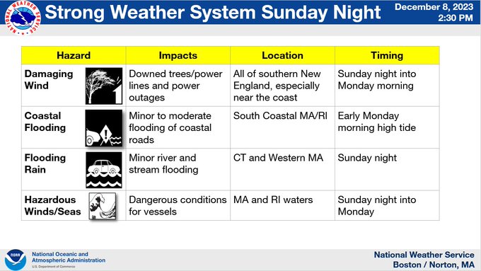
The multi-hazardous system from Sunday night through Monday will likely pound Massachusetts with strong winds and soaking rains during the unseasonably warm storm. Power outages will be possible.
Coastal flooding is also a concern, along with dangerous marine conditions.
“It will be a rather strong system coming into the region Sunday into Monday,” Kyle Pederson, meteorologist at the National Weather Service’s Boston office, told the Herald on Friday.
“Right now, it’s looking like it will be a pretty strong wind event for eastern Massachusetts and Rhode Island,” he added.
Wind gusts could hit 60 mph along the coast, with 40 mph wind gusts for inland areas.
The potential for thunderstorms could lead to more damaging wind gusts, sparking power outages in spots.
“The good thing is that the leaves are now gone from the trees,” Pederson said, noting that helps prevent trees from toppling.
Forecasters are also keeping their eyes on the heavy rain from this storm. There could be between 1 and 3 inches of rain for western Massachusetts, while eastern Massachusetts will likely see up to 1.5 inches of rain.
Some poor drainage flooding will be possible because of leaves clogging storm drains.
“The Monday morning commute could be impacted with poor drainage flooding and high winds,” Pederson said. “Also, any trees and power lines that blew down would cause issues on the road.”
There’s also a chance for coastal flooding, primarily for the south facing shores of southeastern Massachusetts.
The National Weather Service has issued a Gale Watch for Nantucket Sound, Vineyard Sound and Buzzards Bay. Strong winds could cause hazardous seas, which may capsize or damage vessels and reduce visibility.
Seas offshore may build to a height of 12 to 15 feet, while waves closer to the shoreline could be as high as a whopping 8 to 12 feet. There could be coastal erosion along south facing beaches.
A few snow showers across parts of western Massachusetts will be possible Monday afternoon and evening as the system departs. That could lead to some minor accumulations.
Then Tuesday through Thursday should be quiet and dry with no significant weather systems. High temps should be in the upper 30s and low 40s, with overnight lows in the mid-20s to low 30s.


