Massachusetts winter storm watch: ‘Significant snowfall’ likely Monday into Tuesday
Boston hit 60 degrees Saturday, tying record warmth for the day, while Worcester broke its record, reaching 57 degrees.
But the good times in the warmth won’t last much longer.
“You’ll have one more day of it, and winter is coming back,” National Weather Service Boston meteorologist Kyle Pederson told the Herald Saturday evening.
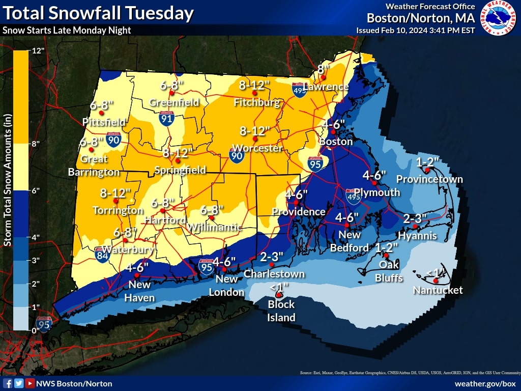
The NWS issued a winter storm watch earlier Saturday that will go into effect late Monday night and last through late Tuesday night, with a solid 4 to 12 inches of snowfall expected across the Bay State.
Boston and areas along the coast are expected to see 4 to 6 inches while areas north and west of the I-95 corridor are anticipated to receive the jackpot of the storm, with 6 to 12 inches possible, NWS’ latest snow map shows. Winds could gust as high as 40 miles per hour, according to the service.
“We haven’t gotten a good snowfall event since the Nor’Easter in January,” Pederson said. “We’re not expecting any wind headlines, and it shouldn’t get close to blizzard headlines. Likely just a normal winter storm.”
A forecast discussion issued Saturday afternoon highlighted the peak of the storm is expected to last most of Tuesday morning, but “substantial precipitation is forecast to linger into the afternoon and evening hours.”
“The Tuesday morning commute will be more impacted further west, with lesser snow impacts closer to the coast,” Pederson said. “That Tuesday afternoon commute will be bad across the board, across much of the state.”
It’s fair to say there will be “many” school cancellations, Pederson added.
An area of concern is a strong likelihood of a coastal flood threat, with astronomical high tides already above normal the past few days. There’s potential for a 2 to 3 feet of surge during Tuesday’s afternoon high tide, the NWS forecast discussion states.
“A winter storm watch is in effect for all of southern New England except for the south coast, Cape, Islands, east slopes of The Berkshires in Hampshire and Franklin counties,” the discussion states. “We expect headlines and the snowfall forecast to evolve over the next day or two, so stay tuned for updates.


