
Tropical Storm Helene forms, forecast to hit U.S. as major hurricane
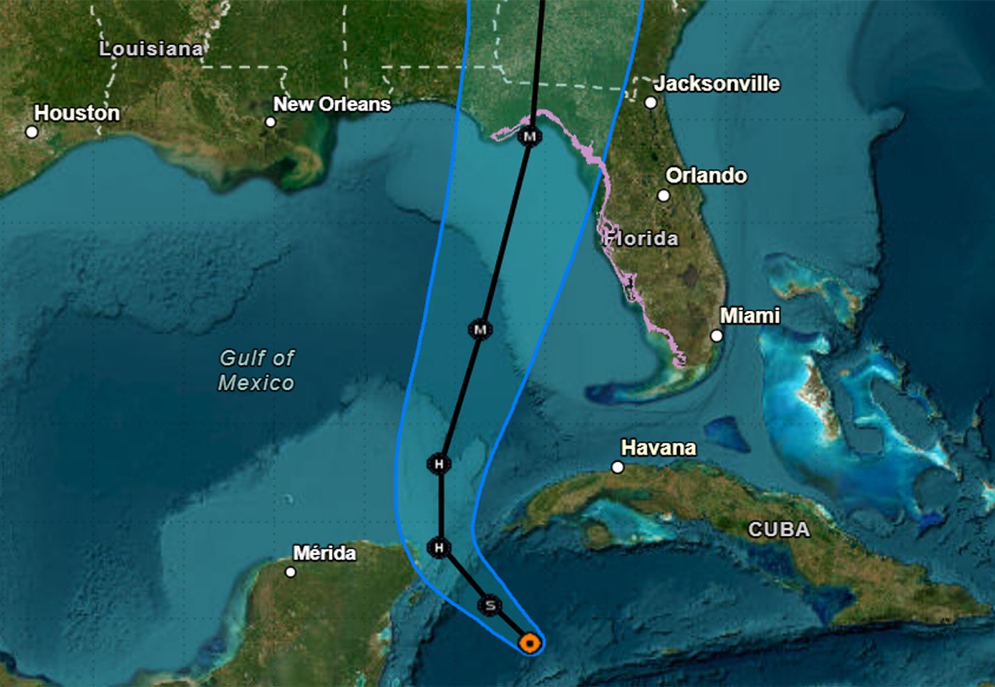
Tropical Storm Helene formed Tuesday morning in the Caribbean, and the National Hurricane Center forecasts it to move north and strike the United States as a major Category 3 hurricane on Thursday night.
Earlier Tuesday, the NHC issued hurricane watches for Florida’s Gulf Coast and warned storm surge could reach as high as 15 feet near its expected landfall.
In its 11 a.m. advisory, the system’s center was located in the northwest Caribbean Sea about 180 miles east-southeast of Cozumel, Mexico and 1780 miles south-southeast of the western tip of Cuba with maximum sustained winds of 45 mph as it moved northwest at 12 mph.
Tropical-storm-force winds extend out 140 miles from its center.
Forecasters predict it will become a hurricane by Wednesday in the Gulf of Mexico and then rapidly intensify into Thursday as it moves across the eastern Gulf of Mexico.
“It is going to be a big storm, and by big I mean not intensity, I mean size,” said NHC Deputy Director Jaime Rhome on Tuesday. “And big storms cause big problems. And that’s one of the take-home messages that I need you to understand.”
He noted tropical storm warnings and watches extending basically from the Florida Keys all the way around to the Panhandle and inland watches including Central Florida.
“The wind swath is going to be huge with this system, and it’s basically going to carve a path right over a good portion of the Florida peninsula, including the highly populated I-4 corridor,” he said. “So if you’re watching from Tampa and Orlando, you’re going to have a big wind event with this, no matter where it goes with respect to the track.”
The storm’s center could target Florida’s Big Bend region, similar to this year’s Hurricane Debby and 2023’s Hurricane Idalia, but could also still shift to the east near Tampa or west to the middle of Florida’s Panhandle.
“All indications are a significant hurricane impacting the Florida Big Bend, but, and this is a big but, the hazards are going to be well removed from the center and well removed from the cone,” Rhome said. “So I don’t want you to look at the cone and say, ‘I’m out of the cone,’ or ‘I’m on the edge of the cone,’ because this wind field, the wind field with this system, is going to be really large — larger than you’re used to seeing with a traditional hurricane.”
Gov. Ron DeSantis issued a state of emergency order Monday for 41 of Florida’s 67 counties, and increased that to 61 on Tuesday. He said during a press conference Tuesday morning that the state also asked for pre-landfall declaration from FEMA.
He said the NHC has never in its history had a forecast for a major hurricane for a system that has yet to even form.
Related Articles
FBI: Son of suspect in Trump assassination attempt arrested on child sexual abuse images charges
Today in History: September 24, Protesting NFL players take a knee
Canton Police Det. Kevin Albert disciplined for drinking on the job
Good swing state polls for Trump show a 2024 election far from decided
Kmart’s blue light fades to black with the shuttering of its last full-scale US store
“I think it’s because there’s some similarities to the track that was taken (by 2018’s Category 5) Hurricane Michael, and I think the thought is that when it’s over the Gulf, especially the more north it goes, rather than east, it has a chance to have a rapid intensification,” DeSantis said. “So we, as always, we prepare for the worst, we hope for the best, but we’d rather be prepared and then have it not reach that level, than just hope that it doesn’t intensify and then be caught not being prepared.”
He said Florida residents still have time Tuesday and early Wednesday to prepare, fill gas tanks, get water and nonperishable food, clean up yards for potential debris and know evacuation zones.
“Right now, regardless of how it forms or the speed right now, you do have time, so take advantage of that time,” he said.
He said more than 18,000 utility linemen are prepped to respond to expected power outages from the hurricane. He also said the state has SpaceX Starlink internet hardware available to deploy if needed to targeted areas. And just as the state deployed in this year’s Hurricane Debby, the state has new flood protection devices primarily for use to protect utility substations.
There are 3,000 Florida National Guard soldiers ready to assist with post-storm assistance as well as Florida State Guard, Florida Fish and Wildlife Commission and county sheriff’s office personnel.
“These resources are being added by the minute, so you’re going to continue to have more linemen brought in. You’re going to continue to have more beef added to these staging areas,” DeSantis said. “We’ll continue to watch the forecast, watch how this develops, see what the time frame is going to be, but we’re going to get something that’s for sure.”
Kevin Guthrie, director of the Florida Division of Emergency Management, said the state expanded its county disaster declaration because of the expected size of the storm.
“This hurricane will have tropical-storm-force winds in excess of 250 miles from the center,” Guthrie said. “That will encompass most of the peninsula from the Space Coast all the way through the First Coast and then on the west coast of Florida, the entire coastal portion of the west coast of Florida.”
DeSantis urged residents to listen to local evacuation orders, and avoid the tragedy seen in 2022’s Hurricane Ian that killed 149 people in Florida, most of whom were caught in major storm surge in southwest Florida. He said evacuation doesn’t have to be far, but they do need to get out from the danger zone.
“Most of the evacuations from the low lying areas, people do not need to even leave their county. In most instances, it’s just getting away from when that water comes, and then as soon as the storm passes, you go out, and hopefully you don’t have major damage,” he said. “But the reality is that water, when you’re there, that’s tough. The wind you can hide from. Anything that’s shelter in Florida is going to be able to withstand the wind, but it’s the water that can be really, really devastating if you remain there when you’re told to evacuate.”
The storm’s breadth means much of the state could face dangerous heavy winds and possible tornado warnings starting Wednesday night with a landfall by Thursday evening. The intensity forecast keeps the system a Category 3 hurricane with 115 mph winds and 140 mph gusts in the Gulf of Mexico approaching Florida’s coast south of Tallahassee by Thursday afternoon.
“The storm surge, wind, and rainfall impacts will extend well away from the center, particularly to the east of the system. In addition, the fast forward speed while it crosses the coast will likely result in farther inland penetration of strong winds over parts of the southeastern UnitedStates after landfall,” NHC senior hurricane specialist Richard Pasch said.
Its immediate threat in the Caribbean also means a hurricane watch is in effect for Cabo Catoche to Tulum, Mexico and the Cuban province of Pinar del Rio with a tropical storm warning in place for Grand Cayman, Rio Lagartos to Tulum, Mexico and the Cuban provinces of Artemisa, and Pinar del Rio, and the Isle of Youth.
Rain over western Cuba and the Cayman Islands could see as much as 12 inches in some places with as much as 6 inches over the eastern Yucatan Peninsula with a risk of flash and urban flooding and minor river flooding. Storm surge up to 4 feet is a threat for parts of Cuba and Mexico.
For Florida, the potential for heavy rains and increased winds is increasing from Wednesday night through Friday.
The NHC said 4-8 inches with some areas getting 12 inches could fall in parts of Florida and the southeastern United States.
National Weather Service Melbourne meteorologist Scott Kelly said the storm looks to have a large wind field once it matures extending far to the east of its center.
“While it is too early to describe specific impacts for east Central Florida, heavy rainfall and tropical-storm-force winds are becoming an increasing concern,” Kelly said. “A few tornadoes will also be possible in the rainbands.”
More rainfall for the Florida peninsula could follow over the weekend after the system has passed through, which is a flooding concern with ground that may have just been deeply saturated already, he said.
The tropical outlook as of 8 a.m. Tuesday, Sept. 23, 2024. (NHC)
While the Caribbean system develops, a second system in the far eastern Atlantic also has a high chance to develop into a tropical depression or storm, the NHC stated in its 8 a.m. Tuesday tropical update.
The tropical wave located near the Cape Verde Islands is producing more concentrated shower and thunderstorm activity since Monday.
“Environmental conditions appear favorable for gradual development of this system, and a tropical depression is likely to form in a few days while it moves westward to west-northwestward across the eastern and central tropical Atlantic,” forecasters said.
The NHC gives it a 30% chance to develop in the next two days and 80% in the next seven.
After Helene, the next name on the 2024 Atlantic hurricane season list is Isaac.
Hurricane season runs from June 1-Nov. 30, with the height of hurricane development running from mid-August into October.


More Stories
Meta accused of profiting from scams targeting US retirees
Advocacy groups have urged Congress to investigate claims that the tech giant benefited from fraudulent campaigns aimed at seniors Several...
Coverd and Albert Wang: Why the Next Chapter of Credit Card Rewards May Be Written Around Everyday Spending
The modern loyalty program occupies a curious place on corporate balance sheets, recorded as a liability that many issuers quietly...
What to Expect from UK Software Development Firms
In all industries, companies are making efforts to adopt digital solutions, automate processes, migrate to the cloud, and operate with...
Austen Hacker: From Concert Pianist to Pharmacy Leader
Success does not always follow a straight line, for Austen Hacker, the path to leadership in pharmacy began behind a...
Jonny Dodge: The Superyacht Influencer and Questions Over Mother City Capital
He has been called the “Superyacht Influencer” by Forbes, featured in Bloomberg, GQ, Tatler and Robb Report, and commands a...
6 Steps to Prepare for Making Tax Digital for Income Tax
Making Tax Digital (MTD) was first introduced by HM Revenue and Customs as part of a wider plan to modernise...