‘Dangerous’ rip currents forecasted along Massachusetts beaches as Hurricane Ernesto passes offshore
If you’re at an ocean beach this weekend, watch out for the rip currents.
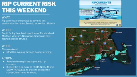
As Hurricane Ernesto passes far offshore, the powerful storm will bring rough surf and strong rip currents to south-facing ocean beaches this weekend.
The National Weather Service issued an alert about the rip currents through Sunday evening.
“Dangerous rip currents expected,” NWS posted. “South facing coastline and beaches of Rhode Island, Martha’s Vineyard, Nantucket. For Cape Cod, the south and east facing beaches on primarily across the Outer Cape.
“Rip currents can sweep even the best swimmers away from shore into deeper water,” the meteorologists added.
Beachgoers are being urged to swim near a lifeguard.
“If caught in a rip current, relax and float,” NWS posted. “Don’t swim against the current. If able, swim in a direction following the shoreline. If unable to escape, face the shore and call or wave for help.”
The Massachusetts Department of Conservation and Recreation was also warning the public about the rip current threat.
Many of the coastal beaches along the state’s northeastern and southern coast will have a “Moderate Risk,” and the area of Horseneck Beach will have a “High Risk” warning.
Related Articles
Sharks close to Cape Cod shore shut down beaches to swimming, white shark spotted chomping on seal
Vineyard Wind turbine trouble sends CEO scrambling; feds issue ‘Suspension Order’
Cape Cod beaches on the Fourth of July: Smooth sailing in Falmouth, Dennis
Cape Cod beaches shut down to swimming after shark sightings
Massachusetts beaches closed amid brutal heat wave, Walden Pond beach ‘underwater’
“DCR urges beachgoers to use caution whenever entering the ocean and to avoid swimming or wading in heavy surf,” DCR posted. “Swim where lifeguards are present, heed all warning signs and flags, and always follow the directions of lifeguards.”
The Nantucket Harbormaster posted that it anticipates flying double red flags and closing the water to swimming on the island’s South Shore.
Hurricane Ernesto was expected to bring a prolonged period of strong winds and storm surge on Bermuda, starting Friday afternoon through Saturday night. Maximum sustained winds remained near 100 mph.
A dangerous storm surge will likely spark significant coastal flooding on Bermuda. Near the coast, the surge will be accompanied by large and destructive waves.
Up to 15 inches of rain will be possible there, causing life-threatening flash flooding.


