
Massachusetts will see a ‘quick burst of snow’ as blizzard cleanup continues
Is it April Fools’ Day already?
Unfortunately, this is (s)no(w) joke.
After the Blizzard of ’26 wreaked havoc across the region to start the week, more snow is on the way. Thankfully this time, it won’t be measured in feet.
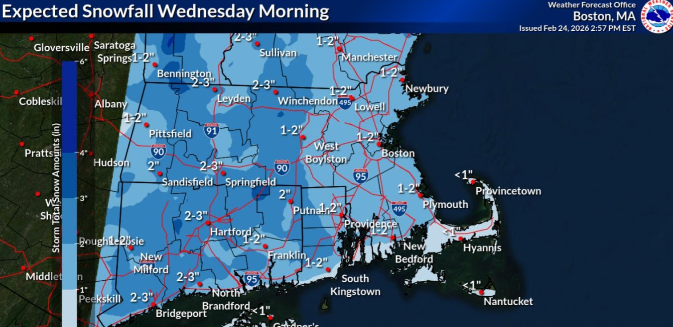
A quick shot of the white stuff is expected on Wednesday, as meteorologists forecast 1 to 3 inches of snow across the region.
Snow should start between 5 and 8 a.m., and end between 11 a.m. and 2 p.m. The snow may end as rain, with the temps rising in the afternoon.
“It will be a quick burst of snow,” National Weather Service meteorologist Hayden Frank told the Herald.
The fast-moving system is expected during the latter half of Boston’s morning rush hour, he noted.
Cameron Stone in Scituate snow blows after the blizzard. (Matt Stone/Boston Herald)
After the snow, temps are expected to jump to around 40 degrees in the afternoon — which could help melt some of the pile up from the monster blizzard.
Meanwhile, forecast models are showing a Thursday-to-Friday system further south and away from the region.
“It should stay south of us,” Frank said. “We’re not expecting anything from that one.”
The weekend should be dry before the risk for more unsettled weather returns to start the week.
“A front moves through sometime in the second half of the weekend, injecting another cold shot of air into the region to start the week,” NWS Boston wrote in its forecast discussion. “Some unsettled weather could return for the start of the week which we will continue to monitor.”
This winter has been well-above normal for snowfall. More than 60 inches of snow (60.4 inches) has already fallen at Boston Logan International Airport — which is two feet more than normal for this point of winter (36.4 inches).
The average total snowfall for a winter at Boston Logan is 49 inches of snow.
During the historic 2015 winter, a whopping 110.6 inches of snow was recorded at Boston Logan.
Related Articles
Massachusetts Blizzard of ’26 cleanup efforts barrel ahead; Boston schools set to reopen
Maura Healey lifts the travel ban for parts of Massachusetts after blizzard
The Blizzard of ’26: Massachusetts pounded by nor’easter that sparks travel ban, power restoration will take days
Gov. Maura Healey issues travel ban in Bristol, Plymouth, Barnstable counties amid historic blizzard of 2026
Editorial: Will Boston’s snow removal Take 2 be a hit or miss?
On Monday during the Blizzard of ’26, several National Weather Service local sites reached blizzard criteria. A blizzard is defined as visibility of 1/4 mile or less and wind speeds (sustained or frequent gusts) of 35 mph or higher, being the prevailing conditions over at least a period of 3 hours.
The airport locations that hit blizzard criteria in Massachusetts were: Boston, Worcester, Bedford, Beverly, Norwood, New Bedford, Chatham, Hyannis, Falmouth, and Martha’s Vineyard. In Rhode Island, the blizzard airport sites were: Providence, Newport, Block Island, Smithfield, and Westerly.


More Stories
Anthony Edwards anota 34, Timberwolves vencen a Trail Blazers 124-121
PORTLAND, Oregon, EE.UU. (AP) — Anthony Edwards anotó 34 puntos y encestó cinco triples para ayudar a que los Timberwolves...
Las tasas de alfabetización infantil en EEUU están bajando. Los pediatras podrían ayudar
Por MAKIYA SEMINERA Para algunos niños pequeños en Columbus, Ohio, las evaluaciones de lectura no comienzan en el aula de...
Canciller alemán llega a China para abogar por comercio justo y ayudas para fin de guerra en Ucrania
Por KEN MORITSUGU y GEIR MOULSON BEIJING (AP) — El canciller de Alemania, Friedrich Merz, se reunirá con los principales...
El Congreso mexicano aprueba la reducción gradual de la jornada laboral de 48 a 40 horas
Por FABIOLA SÁNCHEZ CIUDAD DE MÉXICO (AP) — El Congreso de México aprobó el miércoles la reducción gradual de la...
EEUU y Corea del Sur realizarán ejercicios conjuntos en marzo ante tensión con el Norte
Por KIM TONG-HYUNG SEÚL, Corea del Sur (AP) — Los ejércitos de Estados Unidos y Corea del Sur anunciaron el...
El noreste de EEUU se apresura a retirar la nieve mientras otra tormenta llega a la región
Por JAKE OFFENHARTZ, REBECCA BOONE y HALLIE GOLDEN NUEVA YORK (AP) — Los quitanieves despejaron el paso para ambulancias y...