
More snow on the horizon
Here we snow again.
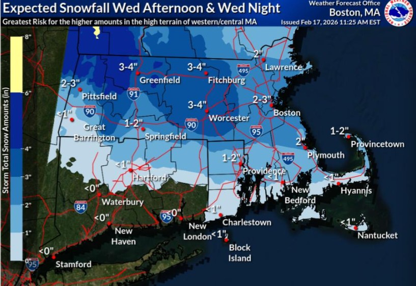
More snow is on the way to the Bay State for Wednesday, according to the National Weather Service — which has issued a “Winter Weather Advisory” for the afternoon and evening commute.
Boston could get up to 3 inches of snow, while localized amounts of 5 inches of snow are possible in central and western Massachusetts.
There’s also the potential for a trace of ice accretion. Untreated roads are expected to be slippery.
“Travel will likely be impacted Wednesday afternoon and Wednesday night due to low visibility at times and snow covered roads,” NWS Boston wrote in its advisory for central and western Mass.
“Plan on extra travel time,” NWS Boston added. “Slow down and use caution while traveling.”
It’s a challenging forecast when it comes to the precipitation type and where a narrow band of snow sets up, NWS noted.
For the Boston and Providence areas, temps initially may be too warm to allow snow to accumulate, so NWS is forecasting 1 to 3 inches of snow for there. It’s possible NWS will need to extend the Winter Weather Advisories into these areas if things trend a bit colder.
The snow should end shortly after midnight, well ahead of the Thursday morning commute.
Related Articles
Massachusetts could get a few inches of snow before temps jump above freezing
Boston Weather: Warmer seasonal days incoming, more snow
Parts of Massachusetts could get 8 inches of snow amid ‘arctic blast’
Massachusetts could see some ‘snow squalls’ as the extreme bitter cold arrives
Man allegedly stabbed in Dorchester parking spot dispute
Then later this week, a system on Friday into Friday night is expected to bring a mix of snow, freezing rain, and rain to the region.
Models were showing a 15% to 40% chance of 4-plus inches of snow through Saturday along and south of the Mass Pike, with a 40% to 55% chance to the north.
Meanwhile, meteorologists are watching a potential winter storm Sunday into Monday.
“Guidance continues to show a potentially significant winter storm developing off the East Coast Sunday into Monday, but as usual at this time range, we are seeing a large spread in possible storm tracks with anything from an offshore pass to a direct hit on southern New England,” NWS Boston wrote, adding, “It’s just way too soon to lock into any one model solution.”
This storm would bring the potential for coastal flooding and marine impacts, even with a more offshore track. There will be higher astronomical tides Sunday and Monday, so much of the coast could be vulnerable to at least minor coastal flooding and beach erosion.


More Stories
Reform UK becomes first British political party to launch its own podcast
Reform UK is venturing into podcasting with a weekly show that will offer listeners behind-the-scenes access to Nigel Farage and...
Labour’s tax uncertainty is pushing Britain’s wealthiest towards the exit
The majority of Britain’s ultra-wealthy individuals are actively weighing up whether to leave the country, driven not so much by...
Barclays bets on the high street once more with new branches and the return of the bank manager
Barclays is charting a decisive U-turn on the high street, with plans to open new branches across the country and...
Amazon bets on Whole Foods to salvage its troubled UK grocery ambitions
Amazon is dusting itself off for another tilt at Britain’s fiercely competitive grocery sector, this time by converting its abandoned...
OpenAI’s flagship UK data centre hits the buffers in blow to Starmer’s AI ambitions
OpenAI’s much-trumpeted plans to build a major data centre in the north-east of England have ground to a halt, dealing...
Explosion Proof PTZ Cameras — Full 360° Intelligence in Explosive Zones
In a standard office building, a blind spot in your surveillance coverage is an inconvenience. In an oil refinery, a...