
Nor’easter forecast for Massachusetts: Cape and Islands to see heavy snow, face strong wind gusts
The Boston-area can breathe a sigh of relief after last week’s whopper.
But the Cape and Islands are not as lucky.
Heavy snow and strong wind gusts are expected on Cape Cod, Nantucket and Martha’s Vineyard this weekend as a powerful nor’easter hits southeastern Mass.
“Periods of blizzard-like conditions are definitely possible,” National Weather Service meteorologist Bryce Williams told the Herald.
“With the low visibility and strong wind gusts, it’s going to be possible,” he added of potential blizzard-like conditions.
The National Weather Service’s Boston office has issued a “Winter Storm Watch” for the Cape and Islands from late Saturday night to Sunday night.
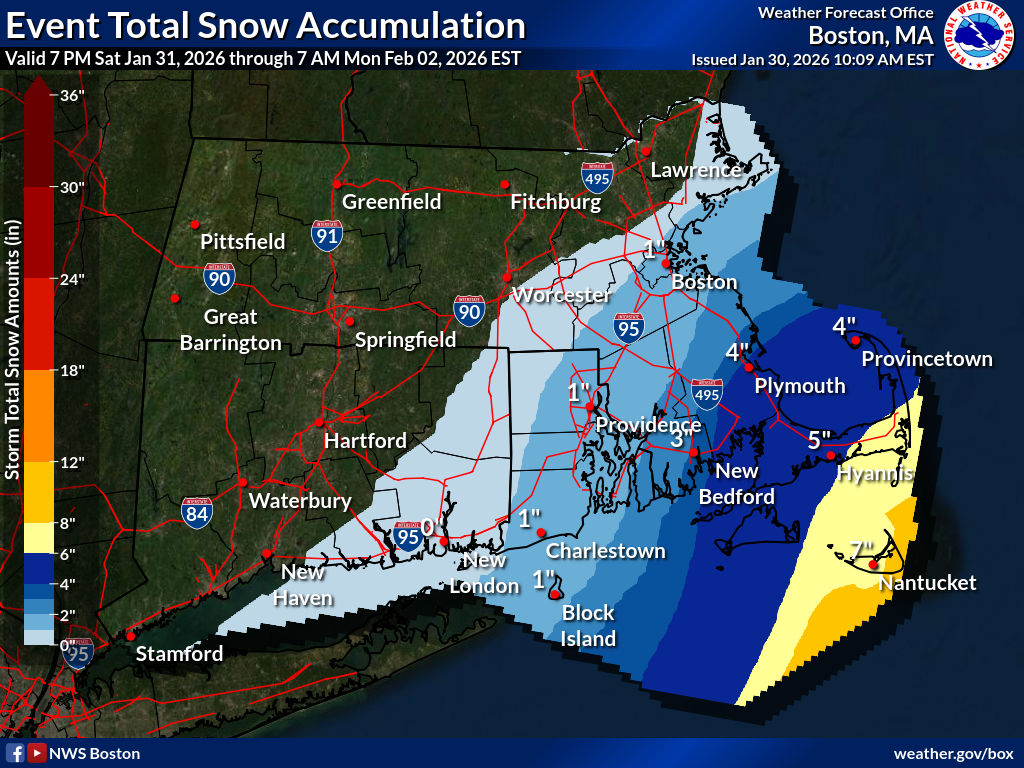
“Heavy snow possible,” NWS Boston wrote. “Total snow accumulations between 4 and 8 inches possible. Winds could gust as high as 45 mph… Travel could be very difficult. Gusty winds could bring down tree branches.”
Nantucket looks like it could be in the jackpot zone, with 6 to 8 inches of snow.
Across Cape Cod, Martha’s Vineyard, and southern Plymouth County, snow amounts are in the 4 to 6 inch range.
Light snow from ocean effect bands could still develop further north and west into the Boston-Providence I-95 corridor into southeast Mass.
While wind gusts might approach 50 mph on the Cape and Islands, the Boston-area could face wind gusts around 40 mph.
Large waves and coastal flooding are also expected from this storm. A “Coastal Flood Watch” continues for the eastern Mass. coastline from Sunday into Monday.
“High astronomical tides combined with at least a 1 to 3 foot storm surge and strong N/NE winds will bring the potential for minor to perhaps moderate coastal flooding along the eastern Massachusetts coast during high tides Sunday morning, Sunday evening, and Monday around midday,” NWS Boston wrote.
“Based upon the projected offshore track of the coastal storm, the highest winds and storm surge should be focused closer to Cape Cod, Nantucket, and Martha’s Vineyard where the higher chances of seeing moderate flooding exists,” NWS Boston added. “However, building seas of 20-25 feet offshore will add additional impacts to the ocean exposed coastline from Plymouth County north to the Merrimack River, so despite lower water levels, those areas could still see moderate impacts.”
Related Articles
Bomb cyclone forecast for Massachusetts: Cape Cod could face blizzard-like conditions
What parts of Massachusetts have the best chance of being slammed by nor’easter bomb cyclone?
Will a monster nor’easter hit Massachusetts this weekend? There are ‘a lot of moving parts’
The storm is expected to qualify for the “bombogenesis” classification — when a system rapidly intensifies. It is popularly referred to as a bomb cyclone.
Bombogenesis can happen when a cold air mass collides with a warm air mass, such as air over warm ocean waters.


More Stories
Middle East war triggering global energy ‘shock’ – IMF
Disruptions to oil and gas supplies will leave lasting “scars” on the world economy, managing director Kristalina Georgieva has said...
What is fueling unrest across the EU?
The bloc is facing an energy crisis due to the Strait of Hormuz disruption, with soaring diesel prices triggering protests...
OECD urges reeves to overhaul ‘inefficient’ UK tax system
Rachel Reeves has been told by one of the world’s most influential economic bodies that Britain’s tax system is holding...
Easter lifts footfall but retailers brace for April cost squeeze
Britain’s high streets enjoyed a welcome lift last month as an early Easter drew shoppers back through the doors, but...
Google takes on Opentable with AI that books your dinner in seconds
Google has fired the opening shot in a battle for Britain’s restaurant booking market, rolling out an artificial intelligence tool...
Retail backers of SEIT face wiping out half their money as green trust raises the white flag
Thousands of small investors who piled into one of London’s best-known green investment vehicles are staring down the barrel of...