
What parts of Massachusetts have the best chance of being slammed by nor’easter bomb cyclone?
The coast might get hammered this weekend.
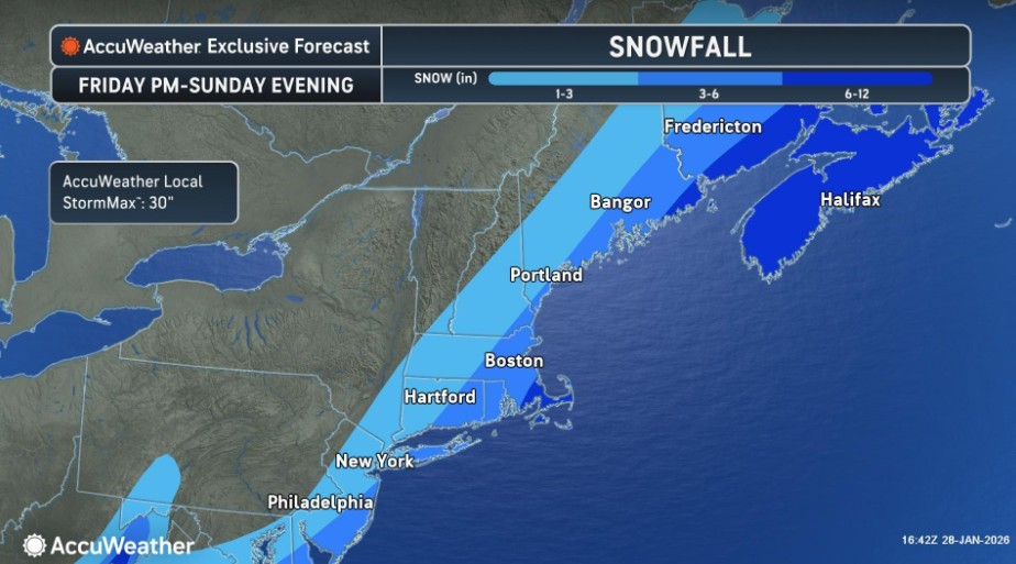
Meteorologists continue to closely track a potent nor’easter for Sunday, and it appears that the best chance for significant snow will be across Cape Cod, Nantucket, and Martha’s Vineyard.
Strong winds and coastal flooding will also be a concern, and blizzard conditions could be possible.
According to AccuWeather, the Cape and Islands have the highest likelihood of 6 to 12 inches of snow, with 3 to 6 inches possible across southeastern New England.
Forecasters caution that there’s still a large amount of uncertainty in the track of the storm, resulting in a wide range of possible impacts.
The nor’easter will likely rapidly strengthen into a bomb cyclone. Bombogenesis can happen when a cold air mass collides with a warm air mass, such as air over warm ocean waters. It is popularly referred to as a bomb cyclone.
Related Articles
Hull Fire fights two-alarm blaze, firefighter falls through floor
Will a monster nor’easter hit Massachusetts this weekend? There are ‘a lot of moving parts’
Police Blotter: Boston EMS warns caution while removing snow
Woman killed by plow in Norwood; injuries reported in dozen crashes
Space-saver season returns to Boston
The National Weather Service’s Boston office says it’s “maintaining a close watch” on the potential coastal storm late this weekend.
Forecast models remain in general agreement that a low-pressure system will develop off the East Coast.
“Despite this consistent signal, models still diverge on the storm track, a critical detail that will dictate both the magnitude of impacts as well as the overall footprint of the storm,” NWS Boston wrote.
“Tracks range from a hit to a full miss with some in between solutions showing a ‘graze’ hit to the Cape/Islands in regards to impacts,” NWS Boston added.
Forecast models show high probabilities for wind gusts greater than 40 mph for the Cape and Islands and the coastal waters.
The potential for coastal flooding and erosion impacts will also need to be monitored due to the potential for strong winds, large waves, and higher astronomical tides.
“It’s still too soon to know the expected impacts, but this shows that the ceiling is high for an impactful storm if everything comes together,” NWS Boston wrote. “Bottom line, we are five days out still. It is expected to see shifts in track from model run to run and continued spread among guidance.
“The track remains uncertain which means we still have a wide range of scenarios, some pointing to an impactful coastal storm across portions of New England and others a miss,” NWS Boston added. “It remains important to not lock in on a solution and look at this from a probabilistic standpoint while noting trends in guidance. The hope is that we gain more clarity in the next day as solutions come into better agreement.”


More Stories
EU nations forced to pay for von der Leyen’s Covid deal
A Belgian court has ordered Poland and Romania to buy $2.2 billion worth of Covid-19 vaccines from Pfizer and BioNTech...
Europeans must pay more for medicine – German pharma giant
Profits have fallen since US President Donald Trump pushed to lower prices for Americans German pharma giant Bayer has warned...
Panic buying drains French gas stations
Hundreds of sites have run dry across the country after price caps triggered a surge in demand amid Middle East...
Ratcliffe backs tory plan to scrap carbon taxes amid industry pressure
Jim Ratcliffe has thrown his support behind Conservative proposals to scrap carbon taxes, intensifying the debate over the cost of...
Bank of England warns Iran war could trigger financial crisis risks
The Bank of England has warned that escalating tensions in the Middle East could push the UK towards a financial...
SpaceX files for record-breaking IPO with $1.75tn valuation target
SpaceX is preparing for what could become the largest stock market debut in history after confidentially filing for an initial...