
Parts of Massachusetts could see 12-plus inches of snow: ‘Slick and hazardous’ conditions
Good luck to all the grocery store workers over the next few days.
The biggest snow storm in years could rock the region this weekend, as the National Weather Service’s Boston office has issued a “Winter Storm Watch” from Sunday morning through Monday evening.
More than 6 inches of snow looks increasingly likely across the area.
“Heavy snow possible,” NWS Boston wrote in its watch. “Potential for snow accumulations between 6 and 12 inches, with localized accumulations over 12 inches possible.”
“Roads, and especially bridges and overpasses, will likely become slick and hazardous,” NWS added. “Plan on slippery road conditions. The hazardous conditions could impact the Monday morning and evening commutes. Travel during the Monday morning commute is likely to be very difficult.”
Local meteorologists continue to caution that the system is still three days away, and that’s an “eternity” in the winter weather forecast world.
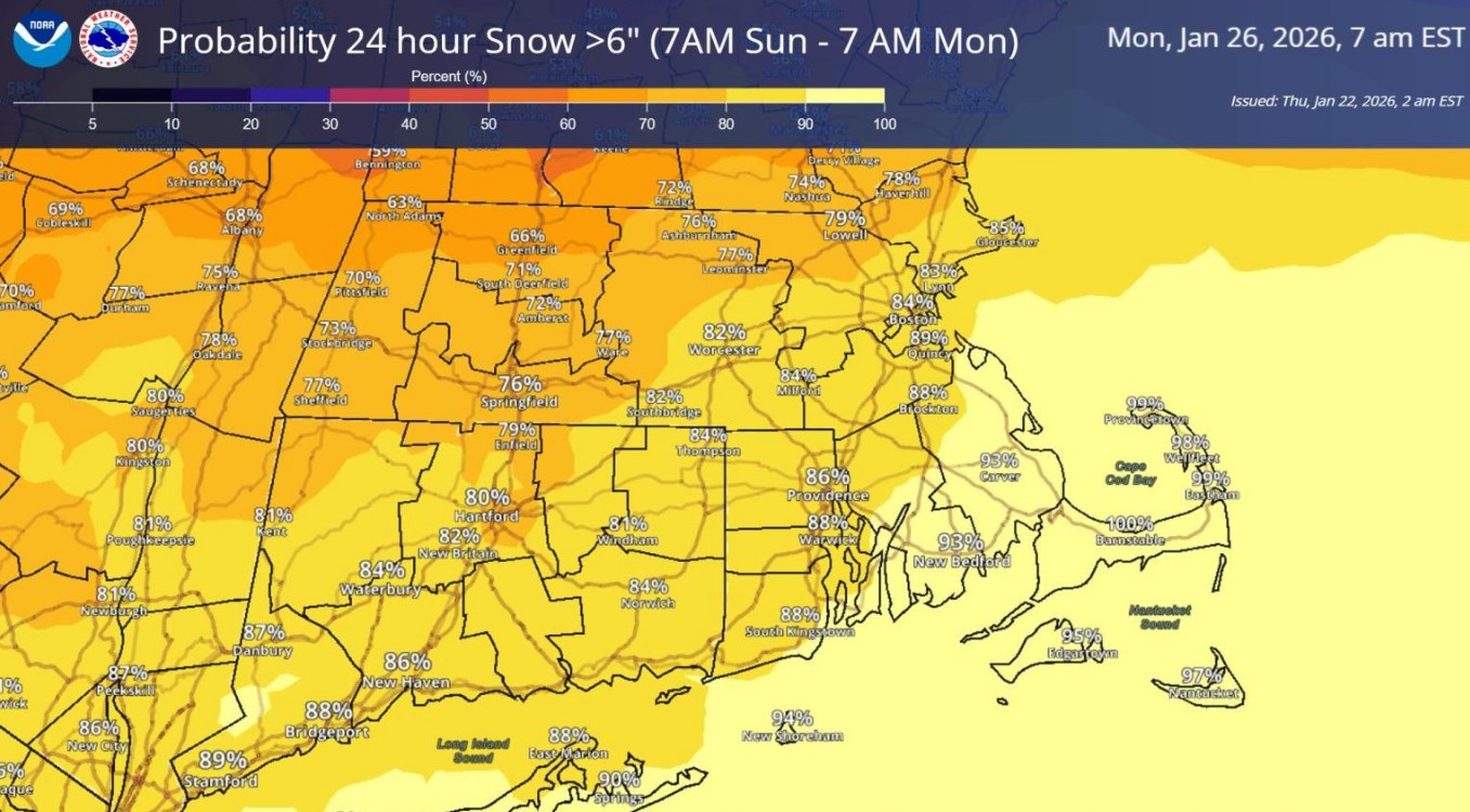
Forecast models show the chances of 6-plus inches of snow is more than 90% in southeastern Massachusetts, and close to 70% in northwest Mass.
Probabilities of a foot of snow are around 70% in southeastern Mass., and 40% in northwest Mass.
“However, keep in mind this a computer model probability that can and will still change based on future trends,” NWS wrote. “The ingredients are there for a significant snow with a plume of subtropical moisture, a very cold antecedent airmass, and strong forcing potential… The progressiveness of this system is also still in question, but the heaviest snow at the moment looks to be during the afternoon through early overnight hours Sunday with lighter snow continuing well into Monday.
“One fortunate aspect of this storm is that it doesn’t look to bring very strong/damaging winds with it (though it will be gusty over the waters),” NWS added. “Finally, any snow that falls isn’t going anywhere fast because the cold sticks around next week.”
Related Articles
Boston weather forecast: ‘Pretty good dumping’ of snow expected
Boston Weather: Up to 6 inches fell in Sunday night storm, ‘arctic air’ incoming
Boston Weather: Snowy MLK Day to kick off week
Snow game? Massachusetts could see ‘plowable snow’ as Patriots face Texans
Boston Weather: Snow, freezing temperatures incoming ahead of warmer weather mid-week
NWS Boston urged residents to monitor the latest forecasts for updates.
“Persons should delay all travel if possible,” NWS Boston wrote in its watch. “Travel Sunday afternoon to Monday morning is likely to become very difficult. If travel is absolutely necessary, drive with extreme caution and be prepared for sudden changes in visibility. Leave plenty of room between you and the motorist ahead of you, and allow extra time to reach your destination.
“Avoid sudden braking or acceleration, and be especially cautious on hills or when making turns,” NWS Boston wrote. “Make sure your car is winterized and in good working order.”


More Stories
Porsche profits crash after costly EV strategy U-turn
The automaker’s operating profits plunged nearly 93% after scrapping an all-electric vehicle program German luxury carmaker Porsche AG has reported...
US borrowed $1 trillion in five months
Over $430 billion has been spent to service the debt, which is approaching $39 trillion, the Congressional Budget Office states...
Green hydrogen plant to be built in Milford Haven with government backing
A new green hydrogen production facility is set to be built in Milford Haven, Wales, marking a significant development for...
Revolut launches UK bank after regulatory approval
Digital banking giant Revolut has officially launched its UK bank after receiving regulatory approval from the Prudential Regulation Authority (PRA),...
Oil price climbs above $90 after ship attack in Strait of Hormuz
Global oil prices have climbed back above $90 a barrel after a cargo vessel was struck by a projectile in...
Churchill to be replaced by wildlife on future Bank of England banknotes
Sir Winston Churchill and other historic figures currently featured on British banknotes are set to be replaced by wildlife under...