
Major Winter Storm to Hit US, Weather Service Warns
By Jack Phillips
The National Weather Service (NWS) on Wednesday forecast that a “major January winter storm” will impact a large section of the United States later this week, and warned that it will be followed by “extreme cold” temperatures.
A notice issued by the service on social media says that snowfall is expected from parts of Texas and Louisiana all the way across the Midwest and a broad section of the South, as well as the Mid-Atlantic and northeastern states, starting on Friday and lasting throughout the weekend.
“Swaths of heavy snow, sleet, and freezing rain from the Southern Rockies and Plains into the Mid-South” will start Friday before it shifts across the East Coast, the agency said.
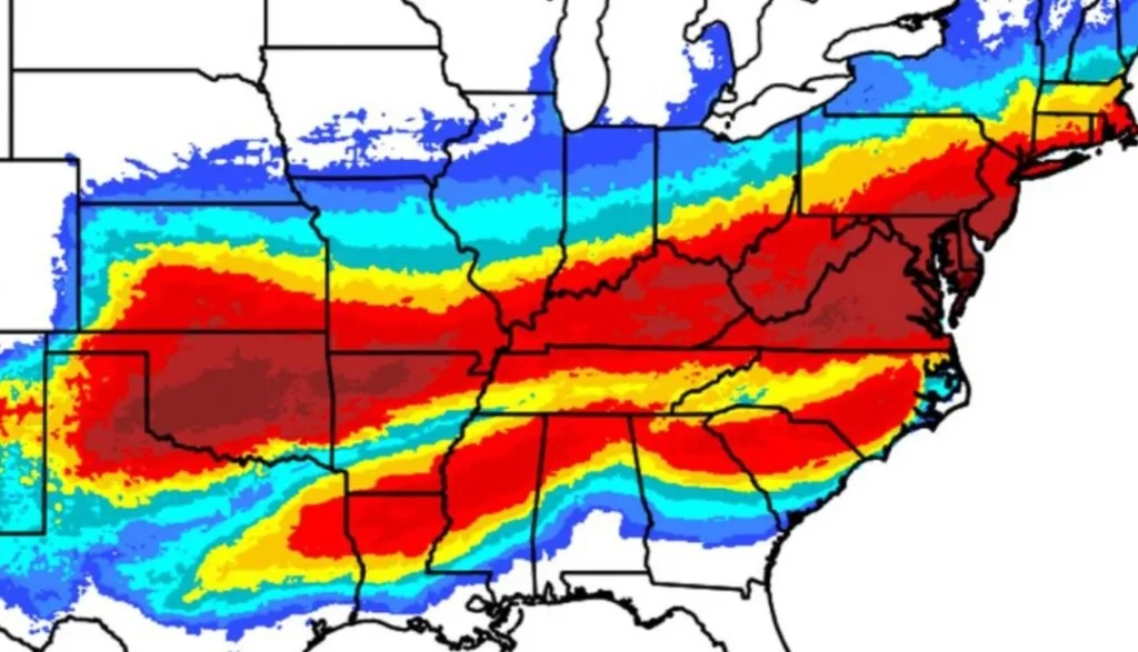
Winter storm advisories were issued for Wednesday in much of the Midwest, Plains, and parts of the southern United States, according to an updated NWS map.
The storm may impact many of the nation’s major airports, including Dallas; Atlanta; Memphis, Tennessee; and Charlotte, North Carolina.
Heavy snow will be expected in the southern portion of the Rocky Mountains and in the south-central Plains regions. The storm will then move eastward across the Mid-Atlantic states, producing snow-covered roadways and low visibility that are likely to create travel chaos, the NWS said.
Meanwhile, freezing rain and sleet will fall to the south of the snowfall zones, namely much of the South and Carolinas, and likely cause power outages, tree damage, and “treacherous travel conditions,” the agency warned.
In Michigan, more than 100 vehicles crashed into each other or slid off an interstate southwest of Grand Rapids on Monday in a separate weather-related incident.
“Global models are painting a concerning picture of what this weekend could look like, with an increasingly strong signal for ice storm potential across North Georgia and portions of central Georgia,” the NWS’s Atlanta office said.
Extreme cold temperatures will prolong any impacts brought by snow or ice accumulation, the agency further warned. Those frigid temperatures will be felt in the eastern two-thirds of the United States as some areas will see “sub-zero and single-digit temperatures” accompanied by wind chills in some areas.
With wind chills factored in, the temperatures may fall to minus 50 degrees Fahrenheit across the northern Plains region, it said. The sub-zero temperatures will reach as far south as the Mid-Atlantic and southern Plains areas, according to the notice.
A National Weather Service map, dated Jan. 21, 2026, shows winter storm advisories in effect across much of the US. NWS
“These wind chills will pose life-threatening risk of hypothermia and frostbite to exposed skin,” the NWS said, adding that power outages caused by the storm may “prolong and compound this risk.” It also advised people to make sure that pets and animals are protected from the cold.
The exact timing of the approaching storm remained uncertain on Wednesday. Forecasters say it can be challenging to predict precisely which areas could see rain and which ones could see ice.
The Associated Press contributed to this report.


More Stories
Earnings Season Is About to Begin, and I Expect Positive Changes
By Louis Navellier We’re approaching another earnings season, starting in mid-April, when many of our stocks shine the brightest. Some...
These Detransitioners Sued for Medical Malpractice, but Will They Get Their Day in Court
By Darlene McCormick Sanchez Prisha Mosley thought that she would get her day in court when the North Carolina Legislature...
Cyber Crimes Costing Americans Nearly $21 Billion: FBI
By Naveen Athrappully The FBI released its 2025 Internet Crime Report, revealing that Americans were being defrauded to the tune...
Iran’s Revolutionary Guard Warns Oil Will Be Cut Off ‘For Years’
By Jack Phillips Iran’s Islamic Revolutionary Guard Corps warned on April 7 that the paramilitary group would attempt to block...
California Leads Nation in Diesel Price Spike
By Bill Pan Diesel prices are rising across the nation, and California is taking an especially hard hit, as recent...
Trump Endorses Steve Hilton in Heated Race for California Governor
By Jill McLaughlin Republican Steve Hilton captured President Donald Trump’s endorsement on April 5 in his quest to become the...