
Arctic air sweeps south as Pacific Northwest on guard after flooding
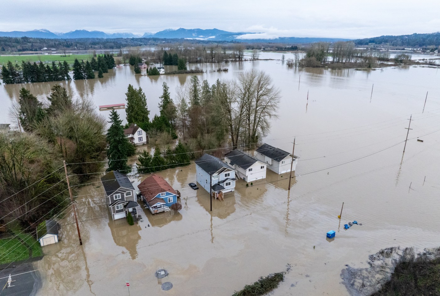
MONROE, Wash. — A blast of arctic air swept south from Canada and spread into parts of the northern U.S., while residents of the Pacific Northwest braced for possible mudslides and levee failures from floodwaters that are expected to be slow to recede.
The catastrophic flooding forced thousands of people to evacuate, including Eddie Wicks and his wife, who live amid sunflowers and Christmas trees on a Washington state farm next to the Snoqualmie River. As they moved their two donkeys to higher ground and their eight goats to their outdoor kitchen, the water began to rise much quicker than anything they had experienced before.
As the water engulfed their home Thursday afternoon, deputies from the King County Sheriff’s Office marine rescue dive unit were able to rescue them and their dog, taking them on a boat the half-mile (800 meters) across their field, which had been transformed into a lake. The rescue was captured on video.
Another round of rain and wind is in store for the region as early as late Sunday, forecasters said.
“Bottom line at this point in time is we’re not done despite the sunny conditions that we have across western Washington at this point,” said Reid Wolcott, a meteorologist with the National Weather Service in Seattle.
“There is yet more still to come in terms of in terms of wind, in terms of rain, in terms in terms of flooding,” he said. “And Washingtonians need to be prepared for additional impacts, additional flooding, tree damage, power outages, etc.”
High winds expected at the end of the weekend and into the first part of week are a concern because the ground is extremely saturated, putting trees at risk of toppling, he said.
In Snohomish County, Washington, north of Seattle, emergency officials on Saturday led federal, state and local officials on a tour of the devastation.
“It’s obvious that thousands and thousands of Washingtonians and communities all across our state are in the process of digging out, and that’s going to be a challenging process,” Washington Gov. Bob Ferguson said.
“It’s going to be expensive,” he said. “It’s going to be time consuming, and it’s going to be potentially dangerous at times. So I think we’re seeing here in Monroe is what we’re going to be seeing all across the state, and that’s what’s got our focus right now.”
As the Pacific Northwest begins to recover from the deluge, a separate weather system already brought dangerous wind-chill values — the combination of cold air temperatures and wind — to parts of the Upper Midwest.
Shortly before noon Saturday, it was minus 12 degrees Fahrenheit in Grand Forks, North Dakota, where the wind-chill value meant that it felt like minus 33 F, the National Weather Service said.
For big cities like Minneapolis and Chicago, the coldest temperatures were expected late Saturday night into Sunday morning. In the Minneapolis area, low temperatures were expected to drop to around minus 15 F, by early Sunday morning. Lows in the Chicago area are projected to be around 1 F by early Sunday, the weather service said.
The Arctic air mass was expected to continue pushing south and east over the weekend, expanding into Southern states by Sunday.
The National Weather Service on Saturday issued cold weather advisories that stretched as far south as the Alabama state capital city of Montgomery, where temperatures late Sunday night into Monday morning were expected to plummet to around 22 F (minus 6 C). To the east, lows in Savannah, Georgia, were expected to drop to around 24 F (minus 4 C) during the same time period.


More Stories
Travelers stranded as Middle East conflict spreads; governments scramble to bring citizens home
By KELVIN CHAN, AP Business Writer LONDON (AP) — Governments scrambled Monday to help travelers get home after the attack...
Hegseth addresses strikes in Iran and says this conflict is ‘not endless’
By MICHELLE L. PRICE and KONSTANTIN TOROPIN WASHINGTON (AP) — Defense Secretary Pete Hegseth on Monday spoke to widening concerns...
Hegseth addresses strikes in Iran and says this conflict is ‘not endless’
By MICHELLE L. PRICE and KONSTANTIN TOROPIN WASHINGTON (AP) — Defense Secretary Pete Hegseth on Monday spoke to widening concerns...
Gas prices spike amid fears of Middle East supply shock
European benchmarks have leapt over 50% as fighting increases shipping risks through the crucial Strait of Hormuz Gas markets around...
Malasia renueva 10 años la licencia de la minera australiana de tierras raras Lynas
Por EILEEN NG KUALA LUMPUR, Malasia (AP) — El gobierno de Malasia renovó por 10 años la licencia de operación...
Palestinos temen que guerra con Irán distraerá al mundo de sus penurias
Por WAFAA SHURAFA, TOQA EZZIDIN y CARA ANNA DEIR AL-BALAH, Franja de Gaza (AP) — Algunos palestinos temen que la...