
Massachusetts, it could feel like 100 degrees: ‘Potentially dangerous’ and chance for severe storms
Now that the rain is gone, it’s time to complain about the brutal heat and humidity.
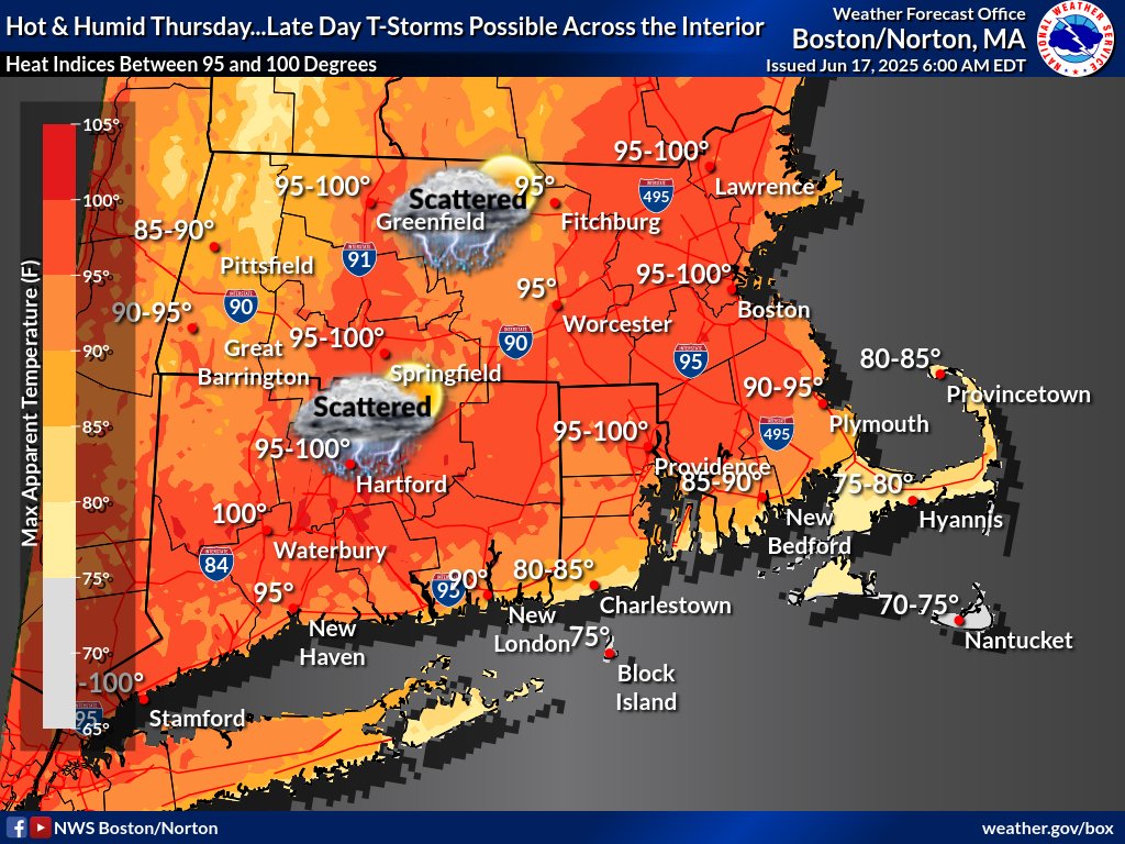
Hazy, hot and humid conditions are on the way for Thursday — when it will possibly feel like a sweltering 100 degrees.
A true taste of summer is on tap with some nasty humidity, as a cold front brings the potential for severe thunderstorms in the afternoon and evening.
“It will be our first really, really hot and humid day of the season,” said Caitlyn Mensch, meteorologist at the National Weather Service’s Boston office.
Dewpoints will spike into the 70s, bringing the heat index “feels like” value to around 100 degrees.
The National Weather Service has issued a “heat advisory” for much of the region, warning that hot temps and high humidity may cause heat illnesses.
Mensch urged people to remain hydrated and to stay in an air-conditioned room. Wear lightweight clothing, and try to limit strenuous activities to early morning or evening, she added.
“Potentially dangerous heat Thursday afternoon with areas across southern New England experiencing ‘feels like’ temperature between the upper 90s into the lower 100s,” reads the NWS Boston forecast discussion, which adds, “It will be humid, dewpoints in the lower 70s is ‘air you can wear.’ ”
Also on Thursday, severe thunderstorms will be possible in the late afternoon and evening as a cold front moves through.
Damaging wind gusts will be the main threat — with large hail, a brief tornado and localized street flooding also possible.
Meteorologists anticipate the main threat for severe weather will begin after 3 p.m. in western New England, and particularly in the 5 to 9 p.m. timeframe as a line of storms.
“While the greater threat for severe weather is mainly west of I-95/I-495, some threat is possible toward sundown in the Boston to Providence corridor, especially if convection can get going sooner,” reads the NWS Boston forecast discussion.
“Those with plans outside during the afternoon, especially from the Berkshires/Litchfield Hills eastward to MetroWest, will want to keep close tabs on the forecast for the afternoon,” NWS Boston adds.
After the brutally hot and humid Thursday, it should be seasonably warm but less humid on Friday into Saturday — with temps in the 80s.
Then a multi-day stretch of significant heat is expected early next week.
“We may begin to see temperatures return into the 90s on Sunday, but the heat peaks in the Mon thru Wed timeframe,” NWS Boston wrote. “Latest ensembles continue to point to heat and humidity levels at least as high as Thurs, if not higher, and also over a stretch of a few days. Heat headlines could be needed at some point if confidence continues to increase.”
Scattered severe storms will be possible on Thursday. Damaging wind gusts are the main threat, with large hail, a brief tornado and localized street flooding also possible. (NWS Boston graphic)


More Stories
From Scotland Yard Commander to Global Security Entrepreneur: Dr Ali Dizaei’s Leadership Story
There are career journeys that follow a straight line, predictable, uniform, and comfortable. And then there are journeys shaped by...
The Naughty AI President: A New Age of Governance
In the race to build better systems of governance, humanity has always chased an impossible ideal: the perfect ruler. Rational,...
Sends shares Q1 2026 business update and product progress
Sends reported Q1 2026 updates sharing news on digital cards, app redesign, ClearBank integration, and fintech industry recognition. Sends, a...
Government doubles down on gaming with £30m funding package as sector eyes global growth
The government has fired the starting gun on a £30 million funding offensive aimed at Britain’s video games sector, urging...
Rising energy costs from Middle East conflict set to leave UK households £480 worse off this year
Rising energy costs triggered by the escalating Middle East conflict are on course to strip nearly £500 from the finances...
UK firms risk being left behind as AI adoption gap widens, warns PwC
British businesses are in danger of being left stranded in the middle of the pack on artificial intelligence, with a...