
Massachusetts could see ‘heavy snow squalls’ before 2 to 3 inches of snow from fast-moving system
Some sneaky snow squalls could cause a few headaches on the roads Tuesday.
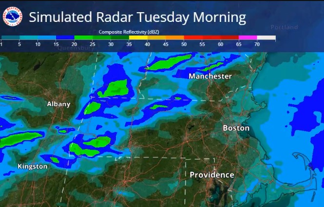
The National Weather Service’s Boston office is warning that there’s a risk for “heavy snow squalls” during the morning commute.
“There could be a quick burst of snow showers, leading to a reduction in visibility for a brief time,” Andrew Loconto, meteorologist at the National Weather Service’s Boston office, told the Herald.
“It may look like a snow globe outside for a little while,” he added.
A cold front will be moving through Tuesday morning — bringing strong gusty winds up to 50 mph, localized snow squalls and some slick travel conditions.
The greatest risk for the snow squalls will be across interior Massachusetts, with the best shot west of Interstate 495.
“A cold front will be accompanied by brief strong wind gusts Tuesday morning along with the potential for a few heavy snow squalls,” reads the National Weather Service’s forecast discussion.
“We will have to watch for hazardous travel in spots for the Tue AM commute as roads may quickly become snow covered with poor visibility/strong wind gusts,” NWS states.
There’s a long history of deadly car crashes associated with intense snow squalls.
Drivers are urged to delay their travel until the squall passes. If you’re in the middle of a squall, reduce your speed on the roads, turn on your hazard lights, and try to exit the roadway.
Related Articles
Boston snowfall total about 5 inches, residents warned of ‘slick roads’ in upcoming freezing weather
Massachusetts Winter Storm Warning: Bay State in store for a potential ‘significant snowmaker’
Massachusetts, get ready for ‘plowable snowfall’ as nor’easter could dump 3-6 inches across the region
NOPE’easter: Massachusetts should only see some light snow as storm passes to the south
Will a monster nor’easter slam Massachusetts? ‘Can’t completely rule out’ a major winter storm
Following the snow squalls Tuesday morning, a fast-moving clipper system is expected to bring snow accumulations to the region late Tuesday night into Wednesday morning.
The National Weather Service is forecasting 2 to 3 inches of snow across the region. The best chance for the higher snowfall amounts may be in western and northern Massachusetts.
Untreated roads may be snow covered and slippery for the Wednesday morning commute.
This will be followed by a cold front Wednesday afternoon and another round of scattered snow squalls.
A short lived arctic airmass then could bring wind chills near zero degrees late Wednesday night and Thursday morning.


More Stories
F1 set to cancel Bahrain and Saudi Arabian Grands Prix amid Middle East conflict
Formula 1 is expected to cancel the Bahrain and Saudi Arabian Grands Prix as the escalating conflict in the Middle...
UK and Ireland strengthen economic partnership as £937m investment set to create 850 jobs
The UK and Ireland have strengthened their economic partnership as leaders gathered in Cork for the second UK-Ireland Summit, where...
UK economy stalls in January as hospitality slowdown drags growth to zero
The UK economy stalled at the start of the year as households cut back on discretionary spending, with restaurants and...
US-Israeli war on Iran wipes billions off Gulf energy revenues – FT
The Middle East escalation has cut off a number of American allies from the vital Strait of Hormuz Oil producers...
Maersk halts operations at Oman port after drone strike widens Iran conflict disruption
Global shipping giant Maersk has suspended operations at the Port of Salalah in Oman after a drone attack struck oil...
Savills agrees $1bn deal to buy Eastdil Secured in major US expansion push
Savills has agreed a deal worth close to $1 billion to acquire US property investment bank Eastdil Secured, marking a...