
Severe thunderstorm watch in effect for Massachusetts throughout Sunday
A week after a tornado watch was issued to Massachusetts and some parts of New England, more inclement weather could hit the region Sunday.
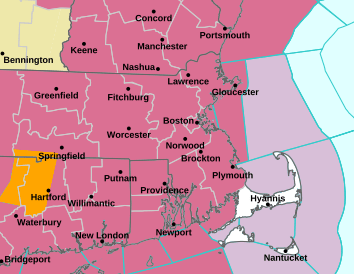
A severe thunderstorm watch is in effect until 7 p.m. Sunday for the Bay State, Rhode Island and most of Connecticut, according to the National Weather Service Forecast office. Southern New Hampshire, Maine and Vermont face a hazardous weather outlook.
A detailed forecast for Massachusetts shows a chance of showers and thunderstorms Sunday afternoon after 2 p.m. with a high around 84 degrees and winds from the southwest coming in around 16 mph.
“Some of the storms could be severe and produce heavy rainfall.” the forecast reads.
This evening, showers and thunderstorms remain likely throughout the state, mainly before 10 p.m. The forecast calls for cloud coverage in the early portion of the evening which should clear up later on. The temperature could drop as low as 61 degrees with winds coming in from the west around 11 mph.
Total rainfall on Sunday could range from a little over an inch to almost three, according to the forecast.
Additionally, the National Weather Service’s storm prediction center upgraded the southern part of New England to an enhanced risk (a level 3 out of 5) for severe weather on Sunday.
“Areal coverage of storms will increase this afternoon with damaging wind the primary threat, but large hail and an isolated tornado is also possible,” NWS said in a post on X, formerly Twitter.
More Stories
China stages military drills around Taiwan to warn ‘external forces’ after US, Japan tensions
By KANIS LEUNG, Associated Press HONG KONG (AP) — China’s military on Monday dispatched air, navy and missile units to...
China stages military drills around Taiwan to warn ‘external forces’ after US, Japan tensions
By KANIS LEUNG, Associated Press HONG KONG (AP) — China’s military on Monday dispatched air, navy and missile units to...
Winter storm brings blizzard conditions and dangerous wind chills
By LEAH WILLINGHAM and JEFF MARTIN, Associated Press A potent winter storm threatened blizzard-like conditions, treacherous travel and power outages in parts...
Winter storm brings blizzard conditions and dangerous wind chills
By LEAH WILLINGHAM and JEFF MARTIN, Associated Press A potent winter storm threatened blizzard-like conditions, treacherous travel and power outages in parts...
US pledges $2B for UN humanitarian aid as Trump slashes funding and warns agencies to ‘adapt or die’
By JAMEY KEATEN and MATTHEW LEE, Associated Press GENEVA (AP) — The United States on Monday announced a $2 billion...
US pledges $2B for UN humanitarian aid as Trump slashes funding and warns agencies to ‘adapt or die’
By JAMEY KEATEN and MATTHEW LEE, Associated Press GENEVA (AP) — The United States on Monday announced a $2 billion...