
As rivers rise, Stillwater, St. Paul prepare for flooding; Minnesota deals with heavy rains
If rain keeps falling and the St. Croix River keeps rising, downtown Stillwater could be looking at a Top 10 flood event next week.
According to the National Weather Service, the river is forecast to hit flood stage – 687 feet – on Thursday, and reach 687.6 feet on June 28, but those numbers could be higher depending on how much rain the area receives through next week.
“At this point, the forecast is getting close to being a significant event,” said Stillwater Mayor Ted Kozlowski.
The river’s 10th highest flood – 687.63 feet – was on June 27, 2014; the record flood was 694.1 feet on April 18, 1965, according to NWS records.
“688 puts us in the top 10,” Kozlowski said. “What’s weird about flooding is it’s about inches. If it hits 694, we’re screwed, but if it’s 691, it’s fine. We’re always right on the edge of it, and we never know how much rain we’re going to get next.
“Right now, we’ve got a pretty good handle on it, but if we get three inches in the next 10 days, things are going to look very difficult downtown,” he said.
City workers Owen Weadge, left, and Charlie Anderson add sandbags to a flood wall in Lowell Park as the rain-swollen St. Croix River slowly overflows its banks in downtown Stillwater, Friday, June 21, 2024. (John Autey / Pioneer Press)
Barriers, sandbags, emergency meeting
City crews on Friday were installing jersey barriers, building a berm and putting sandbags in place on the north side of Lowell Park, the lowest side of the park, said Shawn Sanders, director of the city’s public works department.
Volunteer sandbaggers are not needed at this time, and likely won’t be needed if the river “stays at this elevation,” he said.
“I’m guessing the crest will be Sunday the 30th or Monday the 1st at this point,” Sanders said. “That could change if there is still precipitation they are accounting for.”
City officials on Friday met in an emergency meeting at Stillwater City Hall to declare the city in a state of emergency, but “it’s not as dramatic as it sounds,” Kozlowski said.
The declaration enables city staff to purchase equipment needed to fight the flood without council approval and enables them to apply for federal and state money, if needed, to help with clean-up, Kozlowski said.
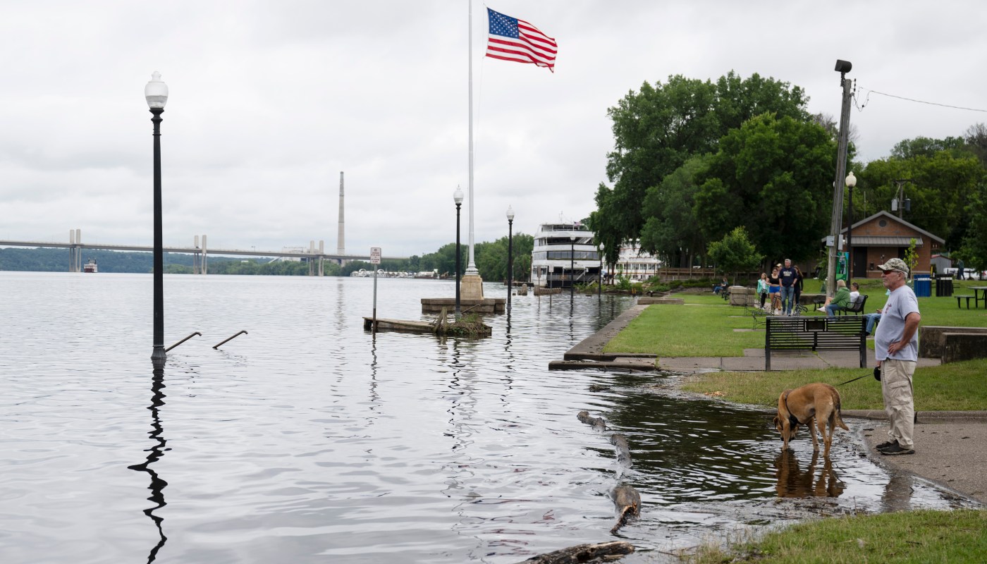
Lowell Park, the park on the St. Croix River in downtown Stillwater, is closed, as are the city-owned parking lots near the park. Shortly after 1 p.m. Friday, Minnesota Department of Transportation crews closed the Stillwater Lift Bridge to walkers and bicyclists.
Workers with the Minnesota Department of Transportation move barricades into place as they close the Stillwater Lift Bridge as the rain-swollen St. Croix River slowly overflows its banks in downtown Stillwater, Friday, June 21, 2024. (John Autey / Pioneer Press)
Crews placed concrete barriers on the non-lift sections of the bridge to act as ballast and raised the lift span approximately 15 feet above the bridge deck to protect the bridge from the rising water. The ballast serves to prevent possible movement of the structure due to flood waters, MnDOT officials said.
Boats with a height less than 15 feet will still be allowed to pass beneath the bridge while the lift span is raised, officials said.
Once flood waters recede, the span will be lowered, ballast will be removed and pedestrian and bicycle traffic can again cross the St. Croix River on the Loop Trail, MnDOT officials said. MnDOT also will resume the regular lift bridge schedule for marine traffic.
Forecast
The flood forecast does not take future precipitation into account outside of the next 48 hours, said Brent Hewett, a meteorologist with the National Weather Service in Chanhassen.
“Obviously, any additional rainfall next week could cause the rises to increase in speed and flood stage,” Hewett said.
More rain is in the forecast, Hewett said, including another 1 to 2 inches in the Stillwater area this weekend. “The heaviest rainfall has shifted south, so that’s good news,” he said. “It now looks like it will fall over northern Iowa.”
The forecast calls for sun on Sunday, then another round of rainfall on Monday evening into Tuesday morning, according to Hewett.
“It does look like we could be drier Wednesday through Friday next week, and then more rain possibly the following weekend,” Hewett said.
Kozlowski said he’s sleeping with his bedroom window open to monitor any potential rainfall himself.
“Forecasting has been all over the place. Paul Huttner is my guy, but even he’s having a hard time,” he said, referring to the MPR News chief meteorologist and “Climate Cast” host.
St. Paul
The road leading to the St. Paul Yacht Club office at Harriet Island Regional Park in St. Paul is closed due to high water levels on Friday, June 21, 2024. (Devanie Andre / Pioneer Press)
Due to large amounts of rainfall expected in the coming days, St. Paul plans to close Shepard and Warner Road for 3.2 miles between Eagle Parkway and U.S. Highway 61 beginning at 6 p.m. on Sunday. The one way street segments that normally connect to Shepard Road will be temporarily converted to two-way traffic open only to access the buildings.
Second Street from Kellogg Boulevard to Sibley Street will be closed and Sibley Street and Jackson Street between Kellogg Boulevard and Second Street will be closed to through traffic.
Bundles of traffic cones surrounding road closed signs are sprinkled down Shepard Road and Warner Road in St. Paul on Friday, June 21, 2024. (Devanie Andre / Pioneer Press)
The current forecast shows the river reaching 20 feet by June 27 which puts the level at major flood stage, according to a spokesperson from the city of St. Paul’s Public Works.
As part of the city’s standard flood response, they are in contact with the property and business owners along the river who might be impacted. The city’s homeless response team also is working with any unsheltered individuals or those in encampments that might be in the areas prone to flooding.
Harriet Island Regional Park will be closed to vehicle traffic and Raspberry Island will close beginning on Sunday, including Wigington Pavilion and the public boat launch.
St. Paul encourages community members to visit stpaul.gov/flood to stay up to date on the latest information on closures.
Fort Snelling State Park
With the expectation that the rising Mississippi and Minnesota rivers will flood the roads and parking lots, the Minnesota Department of Natural Resources announced Friday it will be closing Fort Snelling State Park beginning at 10 p.m. Saturday.
The DNR said the park will remain closed until flood waters “recede and the DNR is able to assess the conditions of facilities and amenities and address any flood-related cleanup and repairs.”
Fort Snelling is the only state park the DNR is currently closing for flooding, but it has already closed some campgrounds, trails, roads and amenities across the state.
Underground mine tours at Lake Vermilion-Soudan Underground Mine State Park are also suspended due to water intrusion in the mine. Surface tours at the Soudan Mine will resume on Saturday. Bison tours at Blue Mounds State Park have been canceled for the weekend due to flooding in the park.
For updated information on DNR closures go to dnr.state.mn.us/trailconditions/index.html.
Road conditions
Travelers can check in with MnDOT’s website at 511mn.org for current conditions.
MnDOT spokesperson Anne Meyer said in an email to the Pioneer Press on Friday that the website is a “great tool for travelers to see the areas of impact due to heavy rain and flooding statewide.”
“We do have several highways that are closed due to flooding or damage, and information may change over the weekend,” Meyer wrote. “511mn.org will have those updates and will be helpful to drivers to plan ahead before their travels.”
Minneapolis
The U.S. Army Corps of Engineers, St. Paul District, announced Friday that it is closing Lower St. Anthony Falls Lock and Dam and Lock and Dam 1, in Minneapolis, to all recreational traffic until further notice due to high flows over 30,000 cubic feet per second.
Flows over this amount are considered unsafe, according to the Corps’ news release. Commercial traffic at these locks would be shut down at 40,000 cubic feet per second, the Corps said.
Northern Minnesota
Several small-town tourist meccas in northern Minnesota continued to be inundated by floodwaters after a deluge of rain earlier this week, prompting the closure of major roads and leaving a costly trail of damage.
On Friday, Minnesota Gov. Tim Walz traveled to St. Louis County, where people in one town paddled through flood-ridden streets in small boats and local officials estimated the floods had caused at least $50 million in damage and prompted the closure of more than 40 roads.
At a news conference in Biwabik, Walz said he expected a presidential disaster declaration might be imminent, but the damage hadn’t yet reached the necessary threshold. Walz encouraged people to keep track of damage, which could help the state secure federal assistance.
“Especially in areas that don’t have a high population density, we’re going to need help,” Walz said. “There’s resources there. The rebuilding will happen.”
This report includes information from the Associated Press.
Related Articles
Here’s what you need to know about the MSRA’s Back to the Fifties Weekend
Lake Superior lighthouse back on the market after deal falls through
After plea withdrawal and subsequent conviction, man gets life for slaying on Iron Range trail
River floods in northeastern Minnesota community of Cook, submerging downtown
Judy Garland’s Minnesota hometown is raising funds to purchase stolen ‘Wizard of Oz’ ruby slippers

More Stories
US court rules against Pentagon in killer AI dispute
The Department of War had ordered contractors to drop Anthropic after it refused to allow military use of its technology...
Which Interior Flooring is Best?
Where do you start when choosing new flooring? When shopping for new flooring a good place to start is to...
Petrol set to top £1.50 a litre as Iran war drives fuel price surge
UK drivers are bracing for a sharp rise in fuel costs, with petrol prices expected to exceed £1.50 per litre...
Dyson hit by £440m sales drop as Trump tariffs bite
Dyson has reported a £440 million drop in annual sales after being hit by US trade tariffs, although the group...
Octopus Investments to cut 20% of staff as AI reshapes asset management
Octopus Investments is set to cut around a fifth of its workforce as it accelerates the adoption of artificial intelligence,...
Next to invest £300m in UK logistics as new warehouse set to deliver £2.5bn boost
Next has unveiled a major expansion of its UK logistics network, committing more than £300 million to new warehouse infrastructure...