
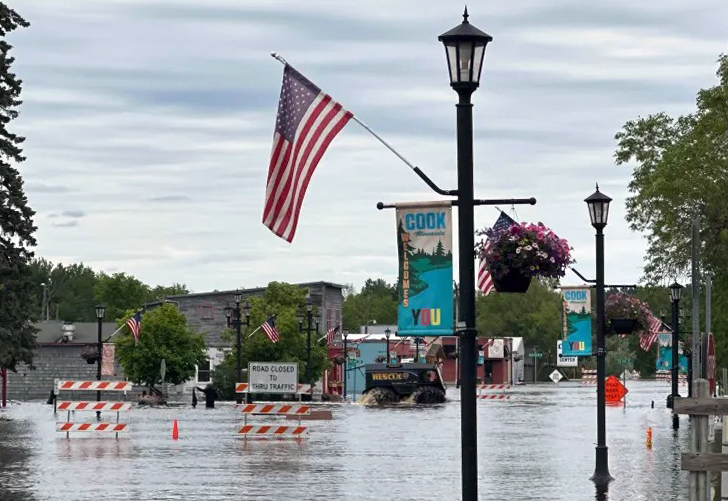
River floods in northeastern Minnesota community of Cook, submerging downtown
The banks of the Little Fork River have flooded downtown roads, businesses and homes in the northeastern Minnesota community of Cook after Tuesday’s storm, which caused flooding and washed out roads from the Iron Range to Wisconsin’s Bayfield County.
It likely hasn’t crested yet.
“Our farm is fine. We’re on a hill,” said Lois Pajari, owner of Cook’s Country Connection petting zoo in Cook. “But our community is in trouble.”
Pajari said there is waist-deep water in some locations in the St. Louis County community of 500, and she’s heard of basements completely full of water up to the home’s main level.
But residents are helping each other out.
Pajari said she was loading gravel from a pit at midnight Wednesday so volunteers could fill sandbags, and she’s caring for a flock of chickens for someone who had to evacuate their home. “Everybody’s sticking together and doing what we can to save what we can,” Pajari said.
While there was initial flash flooding in Cook during Tuesday’s storm — 4.2 inches of rain fell just north of Cook, according to the National Weather Service — the headwaters of the Little Fork near Lake Vermilion saw some of the highest amounts of rain, causing the river to flood in late afternoon Wednesday and keep rising overnight.
Ketzel Levens, meteorologist and a co-manager of the hydrology program at the National Weather Service Office in Duluth, said the 7.6 inches of rain that fell near Tower and the headwaters took some time to reach Cook.
“All of that water is finally able to work its way through our water systems — through those little creeks and rivers — that’s when we start to get that convergence of all that water that was leading to overland flash flooding concerns, (and) now is turning into riverine flooding in those community that are in low-lying areas along rivers,” Levens said.
Water levels on the Little Fork River at Linden Grove, approximately nine miles west of Cook, continue to rise. As of 8:45 a.m. Thursday, the river reached 38.82 feet, 8 feet higher than before Tuesday’s rain, according to the National Water Prediction Service.
“The rate of rise doesn’t appear to be slowing just yet,” Levens said. “So we aren’t seeing any indication of it turning over or at least peaking today. I would expect probably sometime in the next couple of days.”
More rain is on the way, but the heaviest amounts are expected to fall on central and southern Minnesota, Levens said.
According to the National Weather Service, another half-inch to an inch of rain could fall on Cook between Friday afternoon and Saturday evening.
“Any additional rain, what that’s going to lead to is just a longer period of that high water and the recession rate being slower,” Levens said.
County declares disaster
Meanwhile Thursday, the St. Louis County Board of Commissioners called a special meeting to declare the recent flooding events a natural disaster.
County Board Chair Keith Nelson estimated flood waters have inflicted “north of $50 million” in damages so far, based on what he called “a back-of-the-napkin guess.”
Jim Foldesi, the county’s director of public works, said 45 roads remain closed due to flood damage and continued high water. He noted that until those waters recede, it will be impossible to determine the level of damage caused by recent weather.
Foldesi said the flood ranks as the second-most-damaging event he has experienced in his 31-year career with the county, surpassed only by a flood that occurred nearly 12 years ago.
With the weather forecast threatening to drop more rain on the region, Foldesi said the situation could still worsen.
The county’s emergency declaration could open the door for state and federal emergency assistance to flow, helping to assist with repairs. Nelson said he had been in touch with Gov. Tim Walz, who pledged to render state assistance.
Emergency Support Services Director Dewey Johnson said the county is better prepared to handle a challenging situation, following past ordeals, including the unparalleled flood of 2012, which hit Duluth hard. He said the county has 150,000 sandbags in stock.
“We’re in a much better place,” Johnson said.
Officials have been using drones to assess the damage.
Foldesi said special attention has been devoted to parties with access cut off due to washed-out or flooded roadways. Some of these properties remain accessible only by boat.
While the county seeks to assist residents, it is also taking care to document the level of damage, in hopes of receiving state and federal aid to effect needed repairs.
The response has been complicated by the remote and rural nature of many areas impacted by the storm, which Nelson described as roughly “the northern third” of the county.
“Let’s pray we don’t get more rain,” he said, noting that the Northland is entirely saturated at this point, with nowhere for water to go but up.
Reservoirs north of Duluth are near capacity as well, and pending releases in the coming days are expected to impact additional communities downstream, Johnson said.
“It’s been a journey, and it’s not over,” said County Administrator Kevin Gray.
Related Articles
Judy Garland’s Minnesota hometown is raising funds to purchase stolen ‘Wizard of Oz’ ruby slippers
Retired Sartell police chief, 74, fatally struck while bicycling
Man admits fatally shooting northern Minnesota resort guest in a case of mistaken identity
Minnesota family stranded in Brazil with prematurely born baby set for joyous homecoming next week
Minnesota officials weigh options as federal regulators threaten to rescind partnership between Delta Air Lines, Aeromexico


More Stories
US court rules against Pentagon in killer AI dispute
The Department of War had ordered contractors to drop Anthropic after it refused to allow military use of its technology...
Which Interior Flooring is Best?
Where do you start when choosing new flooring? When shopping for new flooring a good place to start is to...
Petrol set to top £1.50 a litre as Iran war drives fuel price surge
UK drivers are bracing for a sharp rise in fuel costs, with petrol prices expected to exceed £1.50 per litre...
Dyson hit by £440m sales drop as Trump tariffs bite
Dyson has reported a £440 million drop in annual sales after being hit by US trade tariffs, although the group...
Octopus Investments to cut 20% of staff as AI reshapes asset management
Octopus Investments is set to cut around a fifth of its workforce as it accelerates the adoption of artificial intelligence,...
Next to invest £300m in UK logistics as new warehouse set to deliver £2.5bn boost
Next has unveiled a major expansion of its UK logistics network, committing more than £300 million to new warehouse infrastructure...