Will the nor’easter be a bust in Massachusetts? Blizzard conditions, power outages possible: Where’s the jackpot snow zone?
Will Old Man Winter drop a cold-hearted dumping on the day before Valentine’s Day?
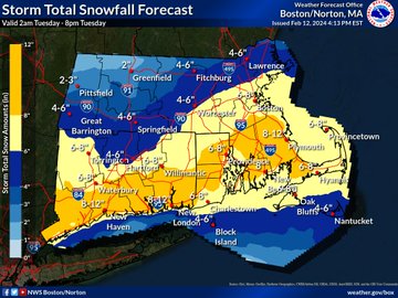
A nor’easter was expected to hit the Bay State on Tuesday, with up to a foot of snow in spots along with possible blizzard conditions, power outages and coastal flooding.
While the forecast models showed a drastic shift to the south at the 11th hour, the Boston-area was still projected to see between 6 and 8 inches of snow.
The jackpot zone was looking like southeastern Massachusetts in Plymouth County, where 12 inches of heavy snow was possible.
“Travel is going to be quite difficult,” Kyle Pederson, a meteorologist with the National Weather Service’s Boston office told the Herald. “It will definitely be a bad day to be out traveling.
“If you can, stay in and watch the snow from home,” Pederson added. “Stay off the roads and stay safe.”
There could be widespread 1 to 2 inches per hour snowfall rates during the day. Even 3 inches of snow per hour will be possible.
The winter storm should be pretty quick hitting. A mix of rain and snow was expected to start late Monday night before a changeover to all snow.
The worst of the snow should be in the 9 a.m. to 3 p.m. window.
“If you’re out driving tomorrow, be prepared for slow travel,” said AccuWeather senior meteorologist Tom Kines.
Snow should come to an end by 4 to 8 p.m., from west to east across the region.
Related Articles
Boston declares snow emergency; Healey tells non-essential state employees to stay home
It’s a nor’easter, kid! Up to a foot of snow possible Tuesday
Massachusetts winter storm watch: ‘Significant snowfall’ likely Monday into Tuesday
Nor’easter could dump ‘significant snowfall’ across Massachusetts, bombogenesis is possible
Massachusetts could see an ‘impactful winter snow storm,’ bombogenesis ‘cannot be ruled out’
Blizzard conditions will be possible, especially on the Outer Cape where the strongest winds are expected, with gusts as high as 55 mph.
Elsewhere, winds will be gusty, blowing 30 to 40 mph over southeastern Massachusetts and along the immediate coasts of the Bay State and Rhode Island.
[Significant Winter Storm] A significant winter storm impacts the region Tuesday morning and afternoon. Latest forecast shifts the heaviest snow further to the south. Strong winds across the Cape and Islands. coastal flooding along east coast with early PM high tide. pic.twitter.com/2yAzE6It8p
— NWS Boston (@NWSBoston) February 12, 2024
Wet snow and strong winds along the coast may result in power outages.
“The biggest risk for outages will be along southeastern Massachusetts,” Pederson said. “There certainly could be snow load issues, and the wind can be a problem.”
The wind gusts and accumulation of wet, heavy snow in some areas could damage trees and knock down power wires.
“National Grid is closely monitoring the weather forecast, and we have crews and personnel in place across Massachusetts ready to respond to any impacts this storm may bring,” said Tim Moore, VP of Electric Operations for New England.
“We’ll be ready to restore service as quickly and safely as possible,” Moore added. “The predicted heavy snow may make roads difficult to travel, and strong winds could have an impact on our restoration efforts. Our crews will work to restore the power systems as soon as it is safe to do so.”
Eversource has been bringing in extra power line and tree crews in advance of the storm.
“We’ve been closely monitoring this storm using several weather forecast models and are planning accordingly, making adjustments to our response as necessary,” said Eversource President of Regional Electric Operations Craig Hallstrom.
“The heavy, wet snow can weigh down tree limbs and branches, possibly bringing them down onto electric lines and equipment, causing damage and power outages,” Hallstrom added. “The hazardous conditions can also make travel challenging for our crews, so we’re staging extra staff and equipment across the state to ensure we’re ready to respond as quickly and as safely as possible wherever our crews are needed.”
Coastal flooding is expected during the Tuesday afternoon high tide along the eastern Massachusetts coast, with significant beach erosion. The storm surge could be 2 to 3 feet.
“Many coastal roads become impassable around high tide,” the NWS coastal flooding warning reads. “Flooding 1 to 2 feet deep affects some coastal roads and low lying areas from Revere and Winthrop through Boston to the South Shore and communities along Cape Cod Bay. Flooding also affects roads near Edgartown Harbor and Nantucket Harbor, and approaches Five Corners in Vineyard Haven.”


