Nor’easter could dump ‘significant snowfall’ across Massachusetts, bombogenesis is possible
After you enjoy mild temps in the 50s this weekend, you might be wondering, “How could it possibly snow in a couple days?”
“Well, it’s February in New England,” AccuWeather senior meteorologist Tom Kines told the Herald on Friday. “It can snow, and it looks like it will.”
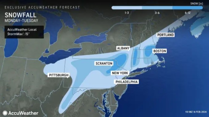
A nor’easter could dump several inches of snow across the region from Monday night into Tuesday, with close to a foot of snow in spots.
Forecasters emphasize that there’s still a lot of uncertainty in the track, intensity and exact timing of the significant coastal storm.
“As far as Massachusetts is concerned, it’s looking like a general 3 to 6 inches of snow,” Kines said. “If you get far enough north and west of Boston away from the ocean influence, it could be more than that, in the 8 to 10 inch range.”
There could be a mix of snow and rain for some areas, depending on how quick the colder air can arrive.
“The places with the least amount of snow could be near the coast,” Kines said.
Related Articles
Massachusetts could see an ‘impactful winter snow storm,’ bombogenesis ‘cannot be ruled out’
Massachusetts snow storm watch: A ‘significant coastal storm’ could hit the region next week
Massachusetts snow totals: After some spots got 8 inches, a ‘little dry spell’ on the way
Snow possible for Monday’s commute, National Weather Service says
Massachusetts snow watch: Western counties to get jackpot
The National Weather Service’s Boston office had not issued any snow prediction maps as of Friday afternoon, but NWS Boston said considerable snowfall could be on the table.
“All we can say at this point is there is potential for a significant snowfall, but snowfall amounts and where heaviest snowfall sets up remains uncertain,” the National Weather Service’s forecast discussion reads.
“This will depend on the track of the low and the rate of storm intensification,” NWS added. “Given we are still 4 days out, further model shifts are expected.”
We’re monitoring the potential for significant snowfall in the northeastern US next week as a weather system moves from the Midwest to off the east coast by Tuesday morning. There is still plenty of uncertainty in precipitation type/amounts.
Updates at https://t.co/VyWINDk3xP pic.twitter.com/SKRihhZBtb
— National Weather Service (@NWS) February 9, 2024
Bombogenesis, also known as a bomb cyclone, remains a possibility with this system, Kines said. Bombogenesis occurs when a storm rapidly intensifies, or strengthens, over a 24-hour period. It can happen when a cold air mass collides with a warm air mass, such as air over warm ocean waters.
“This could get over the ocean and intensify,” Kines said. “There could be a lot of rough surf and beach erosion.”
The storm is expected to bring strong winds, which could spark coastal flooding given the high astronomical tides.
“The Stevens Institute Flood Advisory guidance showing roughly a 1-2 ft surge at this point, which could result in some coastal flooding issues,” the National Weather Service’s forecast discussion reads. “Really need to hone in on the specifics for track/intensity and timing, but will be something to closely monitor given how vulnerable our shorelines are.”


