Massachusetts snow storm watch: A ‘significant coastal storm’ could hit the region next week
Enjoy the sunshine and milder temps while you can.
The Bay State could be on storm watch early next week, with a possible “significant coastal storm” dumping heavy snow across the region.
The forecast models several days out are showing some potentially very strong low pressure systems that could merge, and form a pretty robust storm.
“It’s looking pretty likely that a storm will be passing through the area, some time in the Monday night into Tuesday timeframe,” AccuWeather senior meteorologist Dave Dombek told the Herald five days before the possible storm.
“The details at this point are still very sketchy about how things are going to transpire with this storm,” he added. “The computer models are having a tough time resolving this situation with the combination of systems.”
Related Articles
Massachusetts snow totals: After some spots got 8 inches, a ‘little dry spell’ on the way
Snow possible for Monday’s commute, National Weather Service says
Massachusetts snow watch: Western counties to get jackpot
Massachusetts snow forecast: Up to 8 inches in spots, Boston-area estimate ‘a little tricky’
Parts of Massachusetts could see 6 inches of snow from coastal storm: ‘Travel will be impacted’
The potential winter storm would come after near record-high temps in the upper 50s to lower 60s over the weekend.
“Then there is the potential for a significant coastal storm early next week,” the National Weather Service’s forecast discussion posted. “If this storm comes to fruition, rain and/or heavy snow would be possible depending on the track. Coastal flooding would also be a concern given high astronomical tides and strong winds along the coast.”
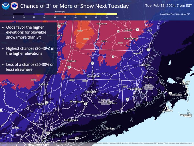
The National Weather Service’s Boston office put out a map with the chances of seeing 3-plus inches of snow next week. Odds favor the higher elevations for more than 3 inches, while there’s a 20% to 30% chance elsewhere.
What about the storm next week? Here are chances of seeing 3″+ of snow Tue. There’s a lot of uncertainty & higher values could shift N or S in next few days.
For now, a storm is likely near SNE. Coastal flooding is also possible on both coasts. Stay tuned!#ctwx #mawx #riwx pic.twitter.com/FEiSmUsEIr
— NWS Boston (@NWSBoston) February 7, 2024
There’s plenty of uncertainty with the system, and higher snow predictions could move north or south in the next few days.
“The track, strength, timing and potential impacts are quite uncertain given this is a Day 6 forecast,” the National Weather Service’s forecast discussion reads.
“All we can say at this point is that there is the potential for a strong storm to impact the region early next week,” NWS added. “This may bring rain and/or heavy snow along with perhaps a period of strong winds along the coast. In addition, astronomical tides are high and if this storm comes to fruition we will have to contend with coastal flooding. Given that both coasts have already been hit hard this winter, they are particularly more vulnerable.”


